 |
|
 |
 |
 |
 |
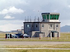
 The Island of Benbecula lies between North Uist and South Uist and its airport serves both, as well as Benbecula itself. The airport is located on a spit of machair, grassy dune land, at the north west corner of Benbecula, adjacent to the main village of Balivanich (Baile Mhanaich).
Aircraft have operated from Benbecula from the late 1930s, and in 1939 an air ambulance was based here. In June 1942 an RAF base was established at Balivanich and for the rest of the war a variety of maritime patrol aircraft operated from here, guarding Atlantic convoys and hunting U-boats.
At the end of the war, RAF Benbecula became Benbecula Airport, helping link Benbecula and the Uists with the rest of Scotland. At the end of the 1950s the military returned to expand the airport and build an Army base nearby. This serves as the headquarters for the missile ranges off the west coast of South Uist.
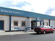
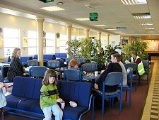
 Travellers using Benbecula Airport today find an attractive terminal, complete with a cafeteria that is worth bearing in mind even for those not planning to travel by air. The terminal is an indication that the airport continues to develop, though the most recent additions are less obvious but equally important barriers to protect the airport from Atlantic storms.
Benbecula Airport is operated by Highlands and Islands Airports Limited (HIAL), which in total operates 10 airports throughout the Highlands and Islands of Scotland. These form an arc including Campbeltown, Islay and Tiree, Barra and Stornoway in the Western Isles, Wick and Inverness on the mainland, Kirkwall in Orkney and Sumburgh in Shetland.
A number of services operate to and from Benbecula. These include links by British Airways to Glasgow; by Highland Airways to Stornoway; and by Loganair to Barra. The last of these is perhaps the most famous and least used of Benbecula's services. The air service to Barra's world famous beach airport by Loganair's Twin Otter aircraft is a unique operation and one of the very best ways to see Benbecula and South Uist.
 Benbecula Airport
Airport Tel No +44 (0)1870 602310
Airport Address - Benbecula Airport, Isle of Benbecula, HS7 5LW
Ticket Sales - British Airways Ticket Desk
Check-in - British Airways
www.undiscoveredscotland.co.uk/benbecula/airport/
Images and information placed above are from http://www.undiscoveredscotland.co.uk/benbecula/airport/, http://www.loganair.co.uk/benbecula_airport.htm
We thank them for the data!
| General Info
|
| Country |
United Kingdom
|
| ICAO ID |
EGPL
|
| Time |
UTC 0(+1DT)
|
| Latitude |
57.481111
57° 28' 52.00" N
|
| Longitude |
-7.362778
007° 21' 46.00" W
|
| Elevation |
19 feet
6 meters
|
| Magnetic Variation |
007° W (01/05)
|
| Operating Agency |
CIVIL GOVERNMENT, (LANDING FEES AND DIPLOMATIC CLEARANCE MAY BE REQUIRED)
|
| Operating Hours |
SEE REMARKS FOR OPERATING HOURS OR COMMUNICATIONS FOR POSSIBLE HOURS
|
| Daylight Savings Time |
Last Sunday in March to last Sunday in October
|
| Communications
|
| TWR |
119.2
|
| ATIS |
113.95
|
| APP |
119.2
|
| Communications Remarks |
|
| ATIS |
Opr 0715-1745Z++ Mon-Fri, 0715-1615Z++ Tue-Thu, 0715-0825 and 0945-1130Z++ Sat, 1245-1430Z++ Sun.
|
| TWR |
Opr 0715-1745Z++ Mon-Fri; 0715-1615Z++ Tue-Thu; 0715-0825Z++, 0945-1130Z++ Sat; 1245-1430Z++ Sun.
|
| APP |
Opr 0715-1745Z++ Mon-Fri, 0715-1615Z++ Tue-Thu, 0715-0825 and 0945-1130Z++ Sat, 1245-1430Z++ Sun.
|
| Runways
|
| ID |
Dimensions |
Surface |
PCN |
ILS
|
| 6/24 |
6024 x 151 feet
1836 x 46 meters |
ASPHALT |
026FBXT |
NO
|
| 17/35 |
4003 x 151 feet
1220 x 46 meters |
ASPHALT |
009FBYT |
NO
|
| Navaids
|
| Type |
ID |
Name |
Channel |
Freq |
Distance From Field |
Bearing From Navaid
|
| VOR-DME |
BEN |
BENBECULA |
086Y |
113.95 |
At Field |
-
|
| DME |
BCL |
BENBECULA |
018X |
- |
At Field |
-
|
| Supplies/Equipment
|
| Fuel |
Jet A1+, Jet A1 with icing inhibitor.
|
| Remarks
|
| FUEL |
Avbl by arng with Loganair Fuels, C01870-603147. (NC-100LL,A1)
|
| OPR HOURS |
Opr 0900-1745Z++Mon and Fri, 0900-1615Z++Tue-Thu, 1000-1130Z++Sat, 1000-1430Z++Sun; OT by arng. Aprt is PPR, 3 hrs PN by fone C01870-602051 or by fax C01870-604826.
|
| RSTD |
All twy clsd exc btn Rwy 06 thld and trml apn. PPR 3 hr ntc. Rwy 17-35 rstd to 12,566 lb or less. Rpt LDA Rwy 24 5807' and Rwy 06 5577'. Non-precision apch 06, thld displ 394'.
|
Runway 06/24
6024 x 151 feet
1836 x 46 meters
| Runway 06
|
| Surface |
ASPHALT
|
| True Heading |
055.0
|
| Latitude |
57.476408
57° 28' 35.07" N
|
| Longitude |
-7.375278
007° 22' 31.00" W
|
| Elevation |
16.0 feet
5 meters
|
| Slope |
0.0°
|
| Landing Distance |
5630 feet
1716 meters
|
| Takeoff Distance |
6024 feet
1836 meters
|
| Displaced Threshold Length |
394 feet
120 meters
|
| Lighting System |
HIRL
S
PAPI |
| Runway 24
|
| Surface |
ASPHALT
|
| True Heading |
235.0
|
| Latitude |
57.485758
57° 29' 08.73" N
|
| Longitude |
-7.350067
007° 21' 00.24" W
|
| Elevation |
13.0 feet
4 meters
|
| Slope |
0.0°
|
| Landing Distance |
6024 feet
1836 meters
|
| Takeoff Distance |
6024 feet
1836 meters
|
| Lighting System |
HIRL
S
PAPI |
Runway 17/35
4003 x 151 feet
1220 x 46 meters
| Runway 17
|
| Surface |
ASPHALT
|
| True Heading |
167.0
|
| Latitude |
57.486886
57° 29' 12.79" N
|
| Longitude |
-7.365747
007° 21' 56.69" W
|
| Elevation |
18.0 feet
5 meters
|
| Slope |
-0.1°
|
| Landing Distance |
4003 feet
1220 meters
|
| Takeoff Distance |
4331 feet
1320 meters
|
| Overrun Length |
328 feet
100 meters
|
| Overrun Surface |
ASPHALT
|
| Lighting System |
PORTABLE
|
| Runway 35
|
| Surface |
ASPHALT
|
| True Heading |
347.0
|
| Latitude |
57.476214
57° 28' 34.37" N
|
| Longitude |
-7.361181
007° 21' 40.25" W
|
| Elevation |
13.0 feet
4 meters
|
| Slope |
0.1°
|
| Landing Distance |
4003 feet
1220 meters
|
| Takeoff Distance |
4003 feet
1220 meters
|
| Lighting System |
PORTABLE
|
Navaids
| BENBECULA
|
| Type |
ID |
Channel |
Freq |
Country |
State
|
| VOR-DME |
BEN |
086Y |
113.95 |
United Kingdom |
-
|
| Latitude |
Longitude |
Airport
|
57.477936
57° 28' 40.57" N |
-7.365300
007° 21' 55.08" W |
EGPL
|
The content above was published at Airports-Worldwide.com in 2005.
We don't guarantee the information is fresh and accurate. The data may be wrong or outdated.
For more up-to-date information please refer to other sources.
|
 |


