 |
|
 |
 |
 |
 |

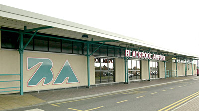
Blackpool Airport is an increasingly busy regional airport serving England's northwest, with scheduled flights to London, Dublin, Belfast and the Isle of Man.
A bureau de change is available near the information desk in the main terminal, open for all international flights.
A bar and buffet in the main concourse area provides convenient food and drinks for arriving passengers. There is a small bar and a children's play area in the international departure lounge. Shops are located in the main concourse and open during airport hours, while there is a duty-free shop in the departures lounge.
The VIP lounge is available upon request and provides a range of business facilities (ph: +44(0) 1253 343434). A post box is located just outside the terminal building.
The airport's single terminal is spread out on one level, making access easy for disabled passengers. Other facilities include dedicated parking, specially designed toilets, lowered phones and wheelchair use.
The information desk is open for all flights (01253 343434).
Squires Gate train station is a five-minute walk from the terminal, with frequent services to and from Preston station, which lies on the national rail network. Buses leave from the airport entrance (ph: 01253 473000).
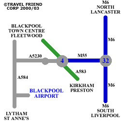
The airport is situated south of Blackpool on the A5230, which turns off the M55 at Junction 4. Car parking is within walking distance of the terminal building.
Airport information: +44(0) 1253 343434
Flight Information: +(0) 1253 402668
 BLACKPOOL AIRPORT
Squires Gate Lane, Blackpool,
Lancashire FY4 2QY
Tel : (01253) 343434 Fax : (01253) 342483
Email : admin at blackpoolairport com
WWW: http://www.blackpoolairport.com/
Images and information placed above are from
http://www.worldparking.co.uk/uk-airports/blackpool.php
http://www.blackpool.g-br.com/tour/tour28.html
http://www.travel-friend.co.uk/airports/airports_blackpool.htm
We thank them for the data!
| General Info
|
| Country |
United Kingdom
|
| ICAO ID |
EGNH
|
| Time |
UTC 0(+1DT)
|
| Latitude |
53.771667
53° 46' 18.00" N
|
| Longitude |
-3.028611
003° 01' 43.00" W
|
| Elevation |
34 feet
10 meters
|
| Type |
Civil
|
| Magnetic Variation |
004° W (01/05)
|
| Operating Agency |
CIVIL GOVERNMENT, (LANDING FEES AND DIPLOMATIC CLEARANCE MAY BE REQUIRED)
|
| International Clearance Status |
Airport of Entry
|
| Daylight Savings Time |
Last Sunday in March to last Sunday in October
|
| Communications
|
| TWR |
118.4
|
| ATIS |
121.75
|
| APP |
119.95
|
| Runways
|
| ID |
Dimensions |
Surface |
PCN |
ILS
|
| 07/25 |
2621 x 98 feet
799 x 30 meters |
ASPHALT |
014FAWT |
NO
|
| 10/28 |
6132 x 151 feet
1869 x 46 meters |
ASPHALT |
030FAWT |
YES
|
| 13/31 |
3533 x 75 feet
1077 x 23 meters |
ASPHALT |
014FAWT |
NO
|
| Supplies/Equipment
|
| Fuel |
Jet A1, without icing nhibitor.
100/130 MIL Spec, low lead, aviation gasoline (BLUE)
|
| Oil |
O-117, 1100, Reciprocating Engine Oil (MIL L 6082)
O-123, 1065,(Dispersant)Reciprocating Engine Oil(MIL L 22851 Type III)
|
| Remarks
|
| FUEL |
(NC-100LL, A1)
|
| LGT |
CAUTION: Rwy 13-31 rwy lgt indicates full rwy wid (118'); not usable wid (75') is delineated by side stripes. Rwy 13 APAPI GS 4 , Rwy 31 APAPI GS 3.25 .
|
| OPR HOURS |
Opr 0600-2300Z++, OT by arng.
|
| RWY |
Rwy 07-25, 13-31 usable rwy edge delineated by side stripes. Rpt LDA Rwy 07 is 2001'; Rwy 25 is 2297'; Rwy 10-28 is 6132'; Rwy 13 is 3041'.
|
Runway 07/25
2621 x 98 feet
799 x 30 meters
| Runway 07
|
| Surface |
ASPHALT
|
| True Heading |
068.0
|
| Latitude |
53.772367
53° 46' 20.52" N
|
| Longitude |
-3.041325
003° 02' 28.77" W
|
| Landing Distance |
2495 feet
760 meters
|
| Takeoff Distance |
2818 feet
859 meters
|
| Displaced Threshold Length |
126 feet
38 meters
|
| Overrun Length |
197 feet
60 meters
|
| Overrun Surface |
ASPHALT
|
| Runway 25
|
| Surface |
ASPHALT
|
| True Heading |
248.0
|
| Latitude |
53.775072
53° 46' 30.26" N
|
| Longitude |
-3.030100
003° 01' 48.36" W
|
| Landing Distance |
2296 feet
700 meters
|
| Takeoff Distance |
2621 feet
799 meters
|
| Displaced Threshold Length |
325 feet
99 meters
|
Runway 10/28
6132 x 151 feet
1869 x 46 meters
| Runway 10
|
| Surface |
ASPHALT
|
| True Heading |
095.0
|
| Latitude |
53.772239
53° 46' 20.06" N
|
| Longitude |
-3.042686
003° 02' 33.67" W
|
| Elevation |
32.0 feet
10 meters
|
| Slope |
-0.1°
|
| Landing Distance |
6132 feet
1869 meters
|
| Takeoff Distance |
6132 feet
1869 meters
|
| Lighting System |
HIRL
BF
PAPI |
| Runway 28
|
| Surface |
ASPHALT
|
| True Heading |
275.0
|
| Latitude |
53.770878
53° 46' 15.16" N
|
| Longitude |
-3.014439
003° 00' 51.98" W
|
| Elevation |
28.0 feet
9 meters
|
| Slope |
0.1°
|
| Landing Distance |
6132 feet
1869 meters
|
| Takeoff Distance |
6132 feet
1869 meters
|
| Lighting System |
HIRL
BP
PAPI |
Runway 13/31
3533 x 75 feet
1077 x 23 meters
| Runway 13
|
| Surface |
ASPHALT
|
| True Heading |
127.0
|
| Latitude |
53.774503
53° 46' 28.21" N
|
| Longitude |
-3.043728
003° 02' 37.42" W
|
| Elevation |
32.0 feet
10 meters
|
| Slope |
-0.1°
|
| Landing Distance |
3055 feet
931 meters
|
| Takeoff Distance |
3533 feet
1077 meters
|
| Displaced Threshold Length |
478 feet
146 meters
|
| Lighting System |
HIRL
PAPI |
| Runway 31
|
| Surface |
ASPHALT
|
| True Heading |
307.0
|
| Latitude |
53.768639
53° 46' 07.10" N
|
| Longitude |
-3.030736
003° 01' 50.65" W
|
| Elevation |
30.0 feet
9 meters
|
| Slope |
0.1°
|
| Landing Distance |
3533 feet
1077 meters
|
| Takeoff Distance |
3533 feet
1077 meters
|
| Lighting System |
HIRL
PAPI |
The content above was published at Airports-Worldwide.com in 2005.
We don't guarantee the information is fresh and accurate. The data may be wrong or outdated.
For more up-to-date information please refer to other sources.
|
 |


