 |
|
Bristol International Airport |
 |
|
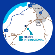 Bristol International is located 8 miles south of Bristol City Centre.
FROM NORTH M5
Leave the M5 at junction 18 (signposted A4 Bristol & Airport). Take the A4 towards Bristol following signs for the airport. Go past Bristol City Football ground and connect with the A38 towards Taunton, the airport is situated 8 miles South of Bristol on the A38.
FROM SOUTH M5
Leave the M5 at Junction 22, at roundabout take 3rd exit signposted A38. At East Brent roundabout joining the A370 take 2nd exit signposted A38 & airport. Continue on this road for approx 11 miles, airport is on the left.
FROM EAST M4
At Junction 20, join the M5 southbound. Exit the M5 at junction 18 (signposted A4 Bristol & Airport). Take the A4 towards Bristol following signs for the airport. Go past Bristol City Football ground and connect with the A38 towards Taunton, the airport is situated 8 miles South of Bristol on the A38.
FROM SOUTH EAST (BATH)
Follow the A4 towards Bristol, bear left onto the A4174 signposted Ring Road. Continue to follow signs for Airport and A38 Taunton.
FROM SOUTH WALES
Follow M4 over the second Severn Crossing. At junction 22 branch left to join M49 (Signposted South West) and then join M5. Leave the M5 at junction 18 (signposted A4 Bristol & Airport). Take the A4 towards Bristol following signs for the airport. Go past Bristol City Football ground and connect with the A38 towards Taunton, the airport is situated 8 miles South of Bristol on the A38.
History:
1927
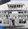 A group of local businessmen managed to raise �6,000 through public subscriptions to inaugurate a flying club at Filton Aerodrome, which became the birthplace of Concorde.
1930
Official opening of Bristol Airport in May by HRH Prince George. During this period Bristol was only the third civil airport in the country.
1939 - 1944
Many discussions take place on the fate of Whitchuch following the war. The general view is that it cannot be developed for post war use and that its future is limited.
1968
A new 5,000 square foot transit shed was constructed and many freight agents were beginning to establish their operations at the airport.
 1973
1973
Saw the collapse of Court Line, which had a dramatic effect on air passenger numbers at all UK airports, not just Bristol.
1991
Brymon Airways continue to dominate the expansion programme with the introduction of an additional service to Edinburgh, introduction of a Newcastle / Aberdeen route and a third Dash 8 aircraft. In addition to Brymon's success Sabena began operating to Brussels and Crossair to Zurich. Freight traffic also increased with scheduled services booming and the Post Office illustrated its commitment by opening up a new sorting office at the airport. Despite a poor year in respect of charter services the final passenger throughput was satisfactory.
2003
Passenger numbers jumped in 2003 to a massive 3.8million. 2003 was also a busy year in terms of new route announcements. Easyjet announced a 6th based unit in October and a range of new routes including Newcastle, Amsterdam, Bilbao, Berlin (starting June 204) and Copenhagen, Bristol Internationals first ever direct flight to Scandinavia. In addition, Bristol International welcomed Air South West, with services to Manchester and Plymouth (starting in 2004), Flybe with an increased range of services including new routes to Toulouse, Bordeaux and Bergerac and finally Isles of Scilly Skybus started services to Newquay.
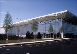
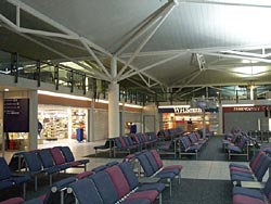
In the Airports Terminal, wireless internet access was launched; WH Smiths and Travelex were extended. The Airport launched an aggressive car park pricing policy, with 8 days parking onsite costing just �33.75 and 15 days parking for just �49. The Airport announced its intention to secure a daily direct schedule service to the USA starting in 2005.
Finally, the Governments White paper on the future of aviation, secured Bristol International status as the Airport for the South West. It estimates that the Airport could expect to handle some 12m passengers by 2030, requiring a longer runway and a terminal extension.
 Bristol International Airport
Bristol
BS48 3DY
Tel: 0870 12 12 747
E-mail: feedback at bristolairport com
WWW: http://www.bristolairport.co.uk/
Images and information placed above are from
http://www.anthonyhuntassociates.co.uk/bia_image_4.htm
http://www.anthonyhuntassociates.co.uk/bia_image_1.htm
We thank them for the data!
| General Info
|
| Country |
United Kingdom
|
| ICAO ID |
EGGD
|
| Time |
UTC 0(+1DT)
|
| Latitude |
51.382669
51° 22' 57.61" N
|
| Longitude |
-2.719089
002° 43' 08.72" W
|
| Elevation |
622 feet
190 meters
|
| Type |
Civil
|
| Magnetic Variation |
003° W (01/05)
|
| Operating Agency |
CIVIL GOVERNMENT, (LANDING FEES AND DIPLOMATIC CLEARANCE MAY BE REQUIRED)
|
| Operating Hours |
24 HOUR OPERATIONS
|
| International Clearance Status |
Airport of Entry
|
| Daylight Savings Time |
Last Sunday in March to last Sunday in October
|
| Communications
|
| TWR |
133.85
|
| RDR |
136.075
125.65
|
| GND |
121.925
|
| ATIS |
126.025
|
| Runways
|
| ID |
Dimensions |
Surface |
PCN |
ILS
|
| 09/27 |
6598 x 151 feet
2011 x 46 meters |
ASPHALT |
051FCWT |
YES
|
| Navaids
|
| Type |
ID |
Name |
Channel |
Freq |
Distance From Field |
Bearing From Navaid
|
| NDB |
BRI |
BRISTOL |
- |
414 |
At Field |
-
|
| Supplies/Equipment
|
| Fuel |
Jet A1, without icing nhibitor.
100/130 MIL Spec, low lead, aviation gasoline (BLUE)
|
| Remarks
|
| CAUTION |
Pilots may experience windshear/turb, especially if the wind is strong Southeasterly (using Rwy 09) or strong Westerly (using Rwy 27). Bird haz. Hi-vis clothingmust be worn on the apn and maneuvering area at all times.
|
| CSTMS/AG/IMG |
Avbl 0700-2200Z Mon-Fri, O/R Sat and Sun btn 1 Nov-30 Apr; (H24 btn 1 May-31 Oct).
|
| FUEL |
Avbl 0500-2330Z and by arng (0430-0100Z Mon-Fri, 0500-0100Z Sat, 0500-2300Z Sun and by arng sum) 100LL. 0800-2000Z++ (NC -100LL, A1).
|
| RSTD |
Rpt LDA Rwy 09 6358'.
|
Runway 09/27
6598 x 151 feet
2011 x 46 meters
| Runway 09
|
| Surface |
ASPHALT
|
| True Heading |
086.0
|
| Latitude |
51.382108
51° 22' 55.59" N
|
| Longitude |
-2.733503
002° 44' 00.61" W
|
| Elevation |
614.0 feet
187 meters
|
| Slope |
-0.2°
|
| Landing Distance |
6598 feet
2011 meters
|
| Takeoff Distance |
6698 feet
2042 meters
|
| Overrun Length |
100 feet
30 meters
|
| Overrun Surface |
ASPHALT
|
| Lighting System |
CL
HIRL
BO
PAPI |
| Runway 27
|
| Surface |
ASPHALT
|
| True Heading |
266.0
|
| Latitude |
51.383231
51° 22' 59.63" N
|
| Longitude |
-2.704672
002° 42' 16.82" W
|
| Elevation |
603.0 feet
184 meters
|
| Slope |
0.2°
|
| Landing Distance |
6155 feet
1876 meters
|
| Takeoff Distance |
7198 feet
2194 meters
|
| Displaced Threshold Length |
443 feet
135 meters
|
| Overrun Length |
600 feet
183 meters
|
| Overrun Surface |
ASPHALT
|
| Lighting System |
TDZL
CL
HIRL
BO
PAPI |
Navaids
| BRISTOL
|
| Type |
ID |
Channel |
Freq |
Country |
State
|
| NDB |
BRI |
- |
414 |
United Kingdom |
-
|
| Latitude |
Longitude |
Airport
|
51.381442
51° 22' 53.19" N |
-2.717544
002° 43' 03.16" W |
EGGD
|
The content above was published at Airports-Worldwide.com in 2005.
We don't guarantee the information is fresh and accurate. The data may be wrong or outdated.
For more up-to-date information please refer to other sources.
|
|


