|
 |
|
||||
|
Machrihanish Golf Club is situated close to the airport and is a championship course which boasts being voted the best first hole in the world. It comes highly recommended from all golfers who have played there. There are two other courses in the area at Southend and Carradale. Refueling Services: Avgas +44 (0) 1955 602201 Keith Wright +44 (0) 1586 553786 Information and Helpful Phone Numbers: Highlands & Islands Airports Ltd +44 (0) 1586 553797 Loganair +44 (0) 1586 552571 Strathclyde Police, Campbeltown +44 (0) 1586 552253 Argyll & the Isles, Loch Lomond, Stirling & Trossachs Tourist Board +44 (0) 1586 552056 Campbeltown Hospital +44 (0) 1586 552224 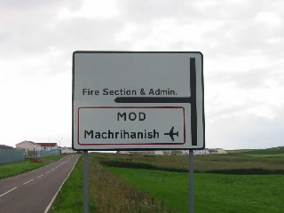 Campbeltown Airport (Machrihanish Airport)
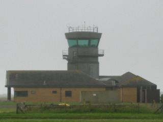
Airport Tel No - +44 (0)1586 552571 Enquiry Desk Tel: 01586 553797 Airport Code: CAL Airport Address - Machrihanish Airport, Campbeltown, Argyll, PA28 6NU Ticket Sales - British Airways Ticket Desk Check-in - British Airways www.hial.co.uk/campbeltown-airport.html Images and information placed above are from http://www.tape7.com/, http://www.loganair.co.uk/campbeltown_airport.htm, http://www.hial.co.uk/campbeltown-airport.html http://www.machairhouse.homestead.com/tiree.html We thank them for the data!
Runway 11/2910003 x 151 feet
|
||||||||||||||||||||||||||||||||||||||||||||||||||||||||||||||||||||||||||||||||||||||||||||||||||||||||||||||||||||||||||||||||||||||||||||||||||||||||||||||||||||||||||||||||||||||||||||||||||||||||||||||||||||||
| Runway 11 | |
|---|---|
| Surface | ASPHALT |
| True Heading | 106.0 |
| Latitude | 55.440994 55° 26' 27.58" N |
| Longitude | -5.709542 005° 42' 34.35" W |
| Elevation | 39.0 feet 12 meters |
| Slope | 0.0° |
| Landing Distance | 9403 feet 2866 meters |
| Takeoff Distance | 10003 feet 3049 meters |
| Displaced Threshold Length | 600 feet 183 meters |
| Lighting System | HIRL
BO PAPI |
| Runway 29 | |
|---|---|
| Surface | ASPHALT |
| True Heading | 286.0 |
| Latitude | 55.433444 55° 26' 00.40" N |
| Longitude | -5.663239 005° 39' 47.66" W |
| Elevation | 39.0 feet 12 meters |
| Slope | 0.0° |
| Landing Distance | 8603 feet 2622 meters |
| Takeoff Distance | 10003 feet 3049 meters |
| Displaced Threshold Length | 1400 feet 427 meters |
| Lighting System | HIRL
BO PAPI |
| MACHRIHANISH | |||||
|---|---|---|---|---|---|
| Type | ID | Channel | Freq | Country | State |
| VOR-DME | MAC | 107X | 116 | United Kingdom | - |
| Latitude | Longitude | Airport |
| 55.430000 55° 25' 48.00" N |
-5.650278 005° 39' 01.00" W |
EGEC |
| CAMPBELTOWN | |||||
|---|---|---|---|---|---|
| Type | ID | Channel | Freq | Country | State |
| NDB | CBL | - | 380 | United Kingdom | - |
| Latitude | Longitude | Airport |
| 55.435631 55° 26' 08.27" N |
-5.688072 005° 41' 17.06" W |
EGEC |
The content above was published at Airports-Worldwide.com in 2005.
We don't guarantee the information is fresh and accurate. The data may be wrong or outdated.
For more up-to-date information please refer to other sources.

 |
|
Copyright 2004-2026 © by Airports-Worldwide.com, Vyshenskoho st. 36, Lviv 79010, Ukraine Legal Disclaimer |
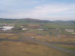
 RAF Machrihanish hosted UK military and NATO base operations until 1997.
The airport runway, at 3,049 metres, is one of the longest in Europe.
Aircraft operations are supported by a Flight Information Service. An
Airport Fire Service is provided on the basis of a Rescue Fire Fighting
Service category 3 airport as detailed in Civil Aviation Publication 168.
RAF Machrihanish hosted UK military and NATO base operations until 1997.
The airport runway, at 3,049 metres, is one of the longest in Europe.
Aircraft operations are supported by a Flight Information Service. An
Airport Fire Service is provided on the basis of a Rescue Fire Fighting
Service category 3 airport as detailed in Civil Aviation Publication 168.