 |
|
 |
 |
 |
 |
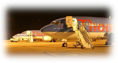
 Coventry Airport is a large freight handling hub and an important flight training centre. It also operates limited passenger flights and can offer parking and a walk-on coach-to-plane service.
The airport has recently opened an executive facility, aimed at the business community.
Coventry airport is situated just of the Toll Bar Roundabout of the A45 Roundabout south Coventry. There are two entrances to the airport, most of the commercial flights require you to go the passenger terminal which is located at Coventry Airport South on Siskin Parkway West, Middlemarch Industrial Estate, you can follow the signs for 'Coventry Airport Passenger Terminalí.
Full Freight Handling Facilities
Coventry Airport is pleased to be able to offer full freight handling facilities. We have particular expertise in adhoc and express freight handling, which we have developed from years of experience working with the local automotive industry.
Security
We are able to provide full freight security screening, please contact Coventry Airport Handling Ltd for further information telephone +44 (0) 24 7651 8862.
Pallet Building
Coventry Airport Handling Ltd are pleased to be able to provide pallet building services. The building is carried out within their own freight handling warehouse which is located at the airport. Please telephone +44 (0) 24 7651 8862 for more information.
 Runways
Runway 23/05 2008Mx46M asphalt PCN48/F/B/X/U
Helicopter FATO 06/24 100Mx23M grass
Navigation Aids
ILS Runway 23 CAT1 system 109.75MHz
ILS Runway 05 CAT1 system 109.75MHz
NDB/LOCATOR 'CT' 363.5KHz
SRA available for Runway 23 and 05 to 2 miles from touchdown.
VDF 119.25MHz / 122.00MHz / 124.8MHz
Coventry Airport
Coventry Airport, Coventry Road, Baginton,
Coventry
West Midlands
England
CV8 3AZ
Telephone: 02476 308638
Fax: 02476 308639
Email Manager ATC: mats at atccoventry co uk
AFTN EGBEZPZX
WWW: http://www.coventry-airport.co.uk/
Images and information placed above are from
http://www.coventry-airport.co.uk/
We thank them for the data!
| General Info
|
| Country |
United Kingdom
|
| ICAO ID |
EGBE
|
| Time |
UTC 0(+1DT)
|
| Latitude |
52.369722
52° 22' 11.00" N
|
| Longitude |
-1.479722
001° 28' 47.00" W
|
| Elevation |
267 feet
81 meters
|
| Type |
Civil
|
| Magnetic Variation |
003° W (01/05)
|
| Operating Agency |
CIVIL GOVERNMENT, (LANDING FEES AND DIPLOMATIC CLEARANCE MAY BE REQUIRED)
|
| Operating Hours |
SEE REMARKS FOR OPERATING HOURS OR COMMUNICATIONS FOR POSSIBLE HOURS
|
| International Clearance Status |
Airport of Entry
|
| Daylight Savings Time |
Last Sunday in March to last Sunday in October
|
| Communications
|
| TWR |
119.25
124.8
|
GND
Avbl when advs by ATC.
|
121.7
|
| ATIS |
126.05
|
| APP |
119.25
|
| Communications Remarks |
|
| ATIS |
Opr 0730-1900Z++ Mon; 2000Z++ Mon-0400Z++ Tue; 0700-1900Z++ and 2000-0400Z++ Tue-Fri; 0730-1900Z++ Sat,Sun.
|
| Runways
|
| ID |
Dimensions |
Surface |
PCN |
ILS
|
| 05/23 |
5988 x 151 feet
1825 x 46 meters |
ASPHALT |
048FBXU |
YES
|
| Supplies/Equipment
|
| Fuel |
Jet A1, without icing nhibitor.
100/130 MIL Spec, low lead, aviation gasoline (BLUE)
|
| Oil |
Available (Types unknown)
|
| Remarks
|
| CAUTION |
Unlgtd obst sur arpt.
|
| FUEL |
(NC-100LL, A1)
|
| LGT |
PAPI Rwy 23 GS 5.5 MEHT 38.
|
| NS ABTMT |
Acft should avoid ovft of areas Binley Woods(05 dep-23 arr); and Stoneleigh(05 arr-23 dep).
|
| OIL |
0-113-117-123-125
|
| OPR HOURS |
Opr 0700-2359Z++ Mon, H24 Tue-Fri, 0001-2130Z++ Sat, 0700-2130Z++ Sun. 2130 Sat-0700Z++ Sun; 2130 Sun-0700Z ++Mon by arng.
|
| RSTD |
PPR 1900Z++ Sat to 0830Z++ Sun, 2100-2359Z++ Sun. Rpt LDA for Rwy 05 is 5889'.
|
Runway 05/23
5988 x 151 feet
1825 x 46 meters
| Runway 05
|
| Surface |
ASPHALT
|
| True Heading |
047.0
|
| Latitude |
52.364400
52° 21' 51.84" N
|
| Longitude |
-1.489281
001° 29' 21.41" W
|
| Elevation |
267.0 feet
81 meters
|
| Slope |
0.0°
|
| Landing Distance |
5988 feet
1825 meters
|
| Takeoff Distance |
6335 feet
1931 meters
|
| Overrun Length |
347 feet
106 meters
|
| Overrun Surface |
CONCRETE.
|
| Lighting System |
HIRL
S
PAPI |
| Runway 23
|
| Surface |
ASPHALT
|
| True Heading |
227.0
|
| Latitude |
52.375508
52° 22' 31.83" N
|
| Longitude |
-1.469572
001° 28' 10.46" W
|
| Elevation |
265.0 feet
81 meters
|
| Slope |
0.0°
|
| Landing Distance |
5568 feet
1697 meters
|
| Takeoff Distance |
6044 feet
1842 meters
|
| Displaced Threshold Length |
420 feet
128 meters
|
| Overrun Length |
56 feet
17 meters
|
| Overrun Surface |
SURFACE UNKNOWN.
|
| Lighting System |
HIRL
X
PAPI |
The content above was published at Airports-Worldwide.com in 2005.
We don't guarantee the information is fresh and accurate. The data may be wrong or outdated.
For more up-to-date information please refer to other sources.
|
 |


