 |
 |
|
||||
|
History
The Eglinton air base was a Fleet Air Arm base named HMS Gannet and was primarily used to provide convoy air cover for the North Atlantic Fleet. After the war the base remained a military establishment into the 1950's at which time the Ministry of defence returned much of the land in and around the base to the original landowners. Some limited commercial activities were undertaken at the airfield during the 1960's when Emerald Airways operated a Glasgow service. During the 1970's the only flying at Eglinton, as it was then known, was carried out by Eglinton Flying Club. This flying club and flight school is still based at the airport. Services Over twenty years after its acquisition the airport is beginning to have the impact on the regional economy envisaged by the Council in 1978. The Government's regional development strategy as outlined in the Shaping Our Future report identifies the city as the regional capital of the North West and Derry City Council is determined to develop the region's infrastructure in order to encourage economic development and inward investment. The City of Derry Airport is being developed as the main gateway to the entire North West region for both business and leisure traffic. The airport is ideally placed to serve not only the city but its natural hinterland in County Derry, North Antrim, Tyrone and Donegal. This cross border dimension has been recognised by both Donegal County Council and the Irish Government who have clearly identified the airport as the principal gateway to the county. During 1998 and 1999 various safety improvements were undertaken at the airport with funding coming from both the British and Irish governments and Derry City Council. These improvements opened the way for larger aircraft to use the facilities at the airport and major route developments took place in the Summer of 1999 with the arrival of Falcon Holidays in May and Ryanair in July. Ryanair operates a direct service between the City of Derry Airport and London Stansted. This low cost service has proved to be extremely popular with both business and leisure travelers he impact of this service on passenger throughput has been dramatic growing from 56,000 in 1998 to approximately 200,000 in 2001. From January 2001 British Airways have operated a twice daily service to Dublin. This route was designated as a Public Service Obligation (PSO) route by the Irish Government, which allows the route to be supported by the Government for at least the next three years. This will allow the airline to build a stable passenger base. The route is proving extremely popular with business travelers who can now fly to Dublin, complete a days business and return the same evening. The service also allows Dublin passengers to complete a day return from Dublin to the North West. The Dublin route compliments the Glasgow and Manchester services also operated by British Airways. The London Stansted service has been extremely popular since its introduction and it now carries some 12,000 passengers per month. The twice daily service attracts both business and leisure travelers because of the convenience and the low cost. Discussions are continuing with Ryanair to improve frequency on this route and to introduce new low cost routes. During the summer months Falcon Holidays provides a package holiday service to Majorca and 2002 sees the first inbound charter to the City of Derry Airport with IT Ireland Tours bringing visitors from Switzerland every week from May to September. Derry City Council is committed to developing the facilities at the City of Derry Airport in order to ensure a direct air link to the region. The airport, in conjunction with the airlines, will continue to develop routes that can be sustained in the long term. As passengers, both business and leisure, increase their usage of the airport, so further improvements can be made in flight frequency, flight timings and destinations served. Information:
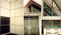
The airport information desk holds a central position in the airport's single terminal building and handles all enquires as well as currency exchange. There is also an ATM and a children's play area. A shop in the main concourse offers a full range of products and convenience items, along with an airport restaurant and bar offering snacks, hot meals and refreshments. There is a cafe in the departures area. A business lounge is located on the first floor and offers complimentary refreshments, TV and video, and photocopy and fax facilities upon request. The airport conference room is also located on the first floor (bookings: +44 (0) 28 7181 3300). Facilities assisting disabled passengers include low-level kerbs and ramps, dedicated parking, specially designed toilets, use of airport wheelchairs, and an induction loop. There are bus and taxi links to Londonderry train station, which serves a daily connection to and from Belfast. For certain flights there are connecting bus services which run to Londonderry city centre, Coleraine, and other regional towns. The airport is located seven miles northeast of Londonderry and is well signposted from the A2. Both car parks are located adjacent to the terminal building. Airport information: +44 28 7181 0784, 28 7181 3300 Airport Address: Airport Road,Eglinton. Co. Derry. BT47 3GY Airport General Telephone: +44 (0) 28 7181 0784 Airport General Fax: +44 (0) 28 7181 1426 Email: info at cityofderryairport com WWW: http://www.cityofderryairport.com/ Images and information placed above are from http://www.worldparking.co.uk/uk-airports/derry.php http://www.stoakes.co.uk/scwderryairport.htm We thank them for the data!
Runway 02/203955 x 148 feet
|
|||||||||||||||||||||||||||||||||||||||||||||||||||||||||||||||||||||||||||||||||||||||||||||||||||||||||||||||||||||||||||||||||||||||||||||||||||||||||||||||||||||||||||||||||||||||
| Runway 02 | |
|---|---|
| Surface | ASPHALT |
| True Heading | 017.0 |
| Latitude | 55.036717 55° 02' 12.18" N |
| Longitude | -7.165397 007° 09' 55.43" W |
| Elevation | 21.0 feet 6 meters |
| Slope | -0.4° |
| Landing Distance | 3520 feet 1073 meters |
| Takeoff Distance | 3955 feet 1205 meters |
| Displaced Threshold Length | 435 feet 133 meters |
| Lighting System | LIRL
PAPI |
| Runway 20 | |
|---|---|
| Surface | ASPHALT |
| True Heading | 197.0 |
| Latitude | 55.047042 55° 02' 49.35" N |
| Longitude | -7.159725 007° 09' 35.01" W |
| Elevation | 5.0 feet 2 meters |
| Slope | 0.4° |
| Landing Distance | 3955 feet 1205 meters |
| Takeoff Distance | 3955 feet 1205 meters |
| Lighting System | LIRL
PAPI |
| Runway 08 | |
|---|---|
| Surface | ASPHALT |
| True Heading | 073.0 |
| Latitude | 55.040397 55° 02' 25.43" N |
| Longitude | -7.175047 007° 10' 30.17" W |
| Landing Distance | 5643 feet 1720 meters |
| Takeoff Distance | 6076 feet 1852 meters |
| Displaced Threshold Length | 433 feet 132 meters |
| Lighting System | CL
HIRL PAPI |
| Runway 26 | |
|---|---|
| Surface | ASPHALT |
| True Heading | 253.0 |
| Latitude | 55.045228 55° 02' 42.82" N |
| Longitude | -7.147328 007° 08' 50.38" W |
| Elevation | 10.0 feet 3 meters |
| Landing Distance | 6076 feet 1852 meters |
| Takeoff Distance | 6076 feet 1852 meters |
| Lighting System | CL
HIRL A3 PAPI |
The content above was published at Airports-Worldwide.com in 2005.
We don't guarantee the information is fresh and accurate. The data may be wrong or outdated.
For more up-to-date information please refer to other sources.

 |
|
Copyright 2004-2026 © by Airports-Worldwide.com, Vyshenskoho st. 36, Lviv 79010, Ukraine Legal Disclaimer |
 As part of the national defences during World War 2 various military bases were established throughout Northern Ireland. Along the eastern coast of Lough Foyle the government located three air bases at Ballykelly, Maydown and Eglinton.
 Derry International Airport serves northwest Ireland and offers regular flights to cities in Ireland and across the UK.