 |
 |
|
||||
|
ABOUT
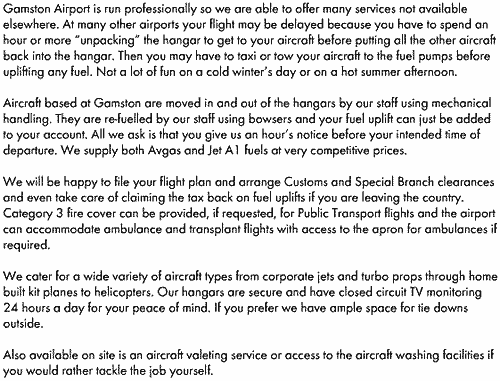
Images and information placed above are from http://www.gamstonairport.co.uk/ We thank them for the data!
Runway 03/215522 x 98 feet
|
||||||||||||||||||||||||||||||||||||||||||||||||||||||||||||||||||||||||||||||||||||||||||||||||||||||||||||||||||||||||||||||||||||||||||||||||||||||||||||||||||||||||||||||||||||||||||||
| Runway 03 | |
|---|---|
| Surface | ASPHALT |
| True Heading | 026.0 |
| Latitude | 53.273733 53° 16' 25.44" N |
| Longitude | -0.956831 000° 57' 24.59" W |
| Elevation | 91.0 feet 28 meters |
| Slope | -0.1° |
| Landing Distance | 4735 feet 1443 meters |
| Takeoff Distance | 5522 feet 1683 meters |
| Displaced Threshold Length | 787 feet 240 meters |
| Lighting System | PAPI |
| Runway 21 | |
|---|---|
| Surface | ASPHALT |
| True Heading | 206.0 |
| Latitude | 53.287378 53° 17' 14.56" N |
| Longitude | -0.945947 000° 56' 45.41" W |
| Elevation | 83.0 feet 25 meters |
| Slope | 0.1° |
| Landing Distance | 4735 feet 1443 meters |
| Takeoff Distance | 5522 feet 1683 meters |
| Displaced Threshold Length | 787 feet 240 meters |
| Lighting System | PAPI |
| GAMSTON | |||||
|---|---|---|---|---|---|
| Type | ID | Channel | Freq | Country | State |
| VOR-DME | GAM | 075X | 112.8 | United Kingdom | - |
| Latitude | Longitude | Airport |
| 53.281389 53° 16' 53.00" N |
-0.947222 000° 56' 50.00" W |
EGNE |
The content above was published at Airports-Worldwide.com in 2005.
We don't guarantee the information is fresh and accurate. The data may be wrong or outdated.
For more up-to-date information please refer to other sources.

 |
|
Copyright 2004-2026 © by Airports-Worldwide.com, Vyshenskoho st. 36, Lviv 79010, Ukraine Legal Disclaimer |
 Gamston Aviation Ltd