 |
|
 Stornoway Airport (STY/EGPO)
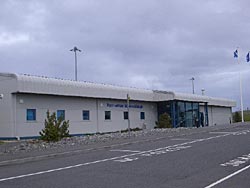
Stornoway Airport is an airfield outside the town of Stornoway on the Isle of Lewis, off the coast of Scotland. The RAF maintained a base at the airport until 1998.
Stornoway Airport is owned by the Highlands and Islands Airports Limited, a company controlled by the Scottish Executive. The airfield was first opened in 1937, and used mainly for military purposes. NATO aircraft used the airport for missions over the North Atlantic and for stop overs to Greenland and the United States.
Nowadays the airfield is mainly used for passenger services, HM Coastguard, and Royal Mail.
Description
 Stornoway Airport provides a key access point to the Western Isles, with flights from Inverness and Glasgow, and inter-island services to Benbecula and Barra. Located on the east coast of Lewis, a few miles from Stornoway, the airport also serves as a base for the search and rescue helicopter operated by HM Coastguard. Air traffic control at Stornoway provides important support services to aircraft flying to and from North America over Iceland. An increasing element of airport business is support services for oil exploration and development in the North Atlantic. The Ministry of Defence recently announced the closure of the RAF base at Stornoway. Aircraft operations are supported by an Air Traffic Control service while on call services to air ambulance and search and rescue flights are assisted by a Flight Information Service Officer. An Airport Fire Service is provided on the basis of a Rescue and Fire Fighting Service category 4 airport as detailed in Civil Aviation Publication 168.
Airport Information
Facilities for the Disabled
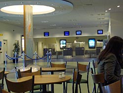
Ambulift facilities are available to assist passengers with impaired mobility during embarkation from aircraft. Wheelchair and limited disabled toilet facilities are available in the Terminal Building. There are ramp facilities at the entrance and staff are always available to assist. Requests for assistance should be made in the first instance to the relevant airline.
Helicopter and Charter Flights
Helicopter Charter Bristows Helicopters +44 (0) 1851 705577
Address:
Stornoway Airport,
United Kingdom,
Isle of Lewis,
HS2 0BN
Tel: +44 (0)1851 702256
Fax: +44 (0)1851 703115
Airport Data: Operating hours Mon-Fri 07:30-16:00 Sat 08:00-14:45 UTC
Airport Code: SYY
Airfield Data: 2 Runways, Fire Category 4
Runway 1: Aircraft size max: B737-200/300
Cargo Facilities: Some handling available; information from ATC
Customs Tel: +44 (0)1851 703626
Op. Hours: 24 hours notice required
WWW: http://www.hial.co.uk/stornoway-airport.html
Images and information placed above are from http://www.azworldairports.com/cfm/frame.cfm?
src=http://www.azworldairports.com/airports/p2720lsi.htm
http://en.wikipedia.org/wiki/Stornoway_Airport
http://www.a2btravel.com/airports/stornoway.asp
http://lily.rupture.net/yak/archives/000799.html
We thank them for the data!
Text from Wikipedia is available under the Creative Commons Attribution/Share-Alike
License; additional terms may apply.
| General Info
|
| Country |
United Kingdom
|
| ICAO ID |
EGPO
|
| Time |
UTC 0(+1DT)
|
| Latitude |
58.215556
58° 12' 56.00" N
|
| Longitude |
-6.331111
006° 19' 52.00" W
|
| Elevation |
26 feet
8 meters
|
| Type |
Civil
|
| Magnetic Variation |
006° W (01/05)
|
| Beacon |
Yes
|
| Operating Agency |
CIVIL GOVERNMENT, (LANDING FEES AND DIPLOMATIC CLEARANCE MAY BE REQUIRED)
|
| Operating Hours |
SEE REMARKS FOR OPERATING HOURS OR COMMUNICATIONS FOR POSSIBLE HOURS
|
| International Clearance Status |
Airport of Entry
|
| Daylight Savings Time |
Last Sunday in March to last Sunday in October
|
| Communications
|
| TWR |
123.5
|
ATIS
0730-1830Z++ Mon-Fri; 0730-1700Z++ Sat; 1230-1830Z++ Sun.
|
115.1
|
| APP |
123.5
|
AFIS
(By arng outside arpt hr)
|
123.5
|
| Runways
|
| ID |
Dimensions |
Surface |
PCN |
ILS
|
| 07/25 |
3281 x 75 feet
1000 x 23 meters |
ASPHALT |
009FBYU |
NO
|
| 18/36 |
7218 x 151 feet
2200 x 46 meters |
ASPHALT |
047FAWT |
YES
|
| Navaids
|
| Type |
ID |
Name |
Channel |
Freq |
Distance From Field |
Bearing From Navaid
|
| VOR-DME |
STN |
STORNOWAY |
098X |
115.1 |
4.7 NM |
283.1
|
| NDB-DME |
SAY |
STORNOWAY |
046X |
431 |
At Field |
-
|
| Supplies/Equipment
|
| Fuel |
Jet A1, without icing nhibitor.
100/130 MIL Spec, low lead, aviation gasoline (BLUE)
|
| Remarks
|
| CAUTION |
Severe downdrafts may be experienced on apch to Rwys 18 and 25. Balloons released at 0515, 1115, 1715 and 2315Z++ dly. Bird haz.
|
| FUEL |
Avbl 0800-1700Z++ Mon-Fri, 0800-1600Z++ Sat, OT O/R. (NC-100LL, A1)
|
| LGT |
PAPI Rwy 07 GS 4 , PAPI Rwy 25 GS 3.5 .
|
| OPR HOURS |
Opr 0800-1830Z++ Mon-Fri, 0800-1700Z++ Sat, 1300-1800Z++ Sun. OT by arng.
|
| RSTD |
PPR. Rwy 07-25 licensed daylt only, not avbl to acft exceeding 12,566 lb, exc when crosswind component exceeds 15 Kt on Rwy 18-36 or when Rwy 18-36 not avbl. Rep LDA for Rwy 18 is 6824'. 394' sec of ASP S of Rwy 36 thld is unfit for use byacft.
|
Runway 07/25
3281 x 75 feet
1000 x 23 meters
| Runway 07
|
| Surface |
ASPHALT
|
| True Heading |
060.0
|
| Latitude |
58.212050
58° 12' 43.38" N
|
| Longitude |
-6.335811
006° 20' 08.92" W
|
| Elevation |
26.0 feet
8 meters
|
| Slope |
-0.2°
|
| Landing Distance |
3281 feet
1000 meters
|
| Takeoff Distance |
3281 feet
1000 meters
|
| Lighting System |
LIRL
PAPI
PORTABLE |
| Runway 25
|
| Surface |
ASPHALT
|
| True Heading |
240.0
|
| Latitude |
58.216536
58° 12' 59.53" N
|
| Longitude |
-6.321047
006° 19' 15.77" W
|
| Elevation |
21.0 feet
6 meters
|
| Slope |
0.2°
|
| Landing Distance |
3281 feet
1000 meters
|
| Takeoff Distance |
3281 feet
1000 meters
|
| Lighting System |
LIRL
PAPI
PORTABLE |
Runway 18/36
7218 x 151 feet
2200 x 46 meters
| Runway 18
|
| Surface |
ASPHALT
|
| True Heading |
174.0
|
| Latitude |
58.225444
58° 13' 31.60" N
|
| Longitude |
-6.332939
006° 19' 58.58" W
|
| Elevation |
16.0 feet
5 meters
|
| Slope |
0.0°
|
| Landing Distance |
6824 feet
2080 meters
|
| Takeoff Distance |
7218 feet
2200 meters
|
| Displaced Threshold Length |
394 feet
120 meters
|
| Lighting System |
HIRL
BF
PAPI |
| Runway 36
|
| Surface |
ASPHALT
|
| True Heading |
354.0
|
| Latitude |
58.205792
58° 12' 20.85" N
|
| Longitude |
-6.329203
006° 19' 45.13" W
|
| Elevation |
15.0 feet
5 meters
|
| Slope |
0.0°
|
| Landing Distance |
7218 feet
2200 meters
|
| Takeoff Distance |
7218 feet
2200 meters
|
| Lighting System |
HIRL
BO
PAPI |
Navaids
| STORNOWAY
|
| Type |
ID |
Channel |
Freq |
Country |
State
|
| VOR-DME |
STN |
098X |
115.1 |
United Kingdom |
-
|
| Latitude |
Longitude |
Airport
|
58.206944
58° 12' 25.00" N |
-6.183056
006° 10' 59.00" W |
EGPO
|
Navaids
| STORNOWAY
|
| Type |
ID |
Channel |
Freq |
Country |
State
|
| NDB-DME |
SAY |
046X |
431 |
United Kingdom |
-
|
| Latitude |
Longitude |
Airport
|
58.215481
58° 12' 55.73" N |
-6.329078
006° 19' 44.68" W |
EGPO
|
The content above was published at Airports-Worldwide.com in 2005.
We don't guarantee the information is fresh and accurate. The data may be wrong or outdated.
For more up-to-date information please refer to other sources.
|
 |


