 |
|
| Grider Field |
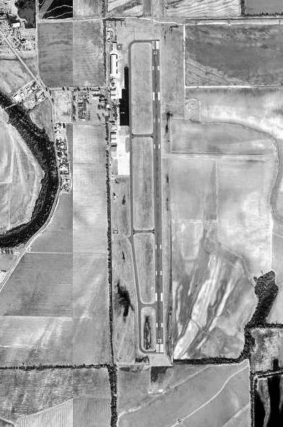 |
| USGS aerial image, 16 February 1994 |
| IATA: PBF – ICAO: KPBF – FAA LID: PBF |
| Summary |
| Airport type |
Public |
| Owner |
City of Pine Bluff |
| Serves |
Pine Bluff, Arkansas |
| Elevation AMSL |
206 ft / 63 m |
| Coordinates |
34°10′28″N 091°56′08″W / 34.17444°N 91.93556°W / 34.17444; -91.93556 |
| Runways |
| Direction |
Length |
Surface |
| ft |
m |
| 18/36 |
5,998 |
1,828 |
Asphalt |
| Statistics (2009) |
| Aircraft operations |
39,875 |
| Based aircraft |
50 |
| Source: Federal Aviation Administration |
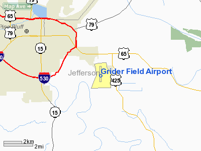
Grider Field (IATA: PBF, ICAO: KPBF, FAA LID: PBF) is a city-owned, public-use airport located four nautical miles (7 km) southeast of the central business district of Pine Bluff, a city in Jefferson County, Arkansas, United States. According to the FAA's National Plan of Integrated Airport Systems for 2009–2013, it is categorized as a general aviation airport. History
Opened in April 1941 with 6,300' x 6,380' open turf field. Began training United States Army Air Corps flying cadets in under contract to Pine Bluff School of Aviation. Assigned to United States Army Air Forces Gulf Coast Training Center (later Central Flying Training Command) as a primary (level 1) pilot training airfield. Had five auxiliary airfields assigned for emergency and overflow landings. Flying training was performed with Fairchild PT-19s as the primary trainer. Also had several PT-17 Stearmans and a few P-40 Warhawks assigned. Also provided flexible gunnery training.
Inactivated on 30 November 1944 with the drawdown of AAFTC's pilot training program. Declared surplus and turned over to the Army Corps of Engineers on 30 September 1945. Eventually discharged to the War Assets Administration (WAA) and returned to being a civil airport.
Facilities and aircraft
Grider Field covers an area of 750 acres (304 ha) at an elevation of 206 feet (63 m) above mean sea level. It has one runway designated 18/36 with an asphalt surface measuring 5,998 by 150 feet (1,828 x 46 m).
For the 12-month period ending May 31, 2009, the airport had 39,875 aircraft operations, an average of 109 per day: 94% general aviation, 5% military and 1% air taxi. At that time there were 50 aircraft based at this airport: 84% single-engine, 12% multi-engine and 4% ultralight.
Renovations
In November 2007, it was announced that Grider Field will undergo an extensive renovation, and modernization project. Also, a new partnership with the University of Arkansas at Pine Bluff has been announced.
The above content comes from Wikipedia and is published under free licenses – click here to read more.
Location
& QuickFacts
| FAA
Information Effective: |
2005-10-27 |
| Airport
Identifier: |
PBF |
| Longitude/Latitude: |
091-56-08.1450W/34-10-23.3090N
-91.935596/34.173141 (Estimated) |
| Elevation: |
206
ft / 62.79 m (Surveyed) |
| Land: |
750
acres |
| From
nearest city: |
4
nautical miles SE of Pine Bluff, AR |
| Location: |
Jefferson
County, AR |
| Magnetic
Variation: |
02E
(2005) |
Owner &
Manager
| Ownership: |
Publicly
owned |
| Owner: |
City
Of Pine Bluff |
| Address: |
200
E. 8th St.
Pine Bluff, AR 71601 |
| Phone
number: |
870-543-1855 |
| Manager: |
Doug
Hale |
| Address: |
Jefferson
County, AR |
| Phone
number: |
870-534-4131 |
Airport
Operations and Facilities
| Airport
Use: |
Open
to public |
| Wind
indicator: |
Yes |
| Segmented
Circle: |
Yes |
| Control
Tower: |
Yes |
| Attendance
Schedule: |
ALL/MON-FRI/0700-1900,ALL/SAT-SUN/0800-1900
FOR ARPT ATTENDANT AFT HRS CALL 870-540-9439. |
| Lighting
Schedule: |
DUSK-DAWN
ACTVT MIRL RY 18/36 AND MALSR RY 18 - CTAF. |
| Beacon
Color: |
Clear-Green
(lighted land airport) |
| Landing
fee charge: |
No |
| Sectional
chart: |
Memphis |
| Region: |
ASW
- Southwest |
| Traffic
Pattern Alt: |
994
ft |
| Boundary
ARTCC: |
ZME
- Memphis |
| Tie-in
FSS: |
JBR
- Jonesboro |
| FSS
on Airport: |
No |
| FSS
Phone: |
870-935-3471 |
| FSS
Toll Free: |
1-800-WX-BRIEF |
| NOTAMs
Facility: |
PBF
(NOTAM-d service avaliable) |
| Federal
Agreements: |
NGRY3 |
Airport
Communications
| CTAF: |
123.000 |
| Unicom: |
123.000
|
Airport
Services
| Fuel
available: |
100LLA
SELF SERVICE FUEL AVBL 24 HRS WITH CREDIT CARD |
| Airframe
Repair: |
MAJOR |
| Power
Plant Repair: |
MAJOR |
Runway
Information
Runway
18/36
| Dimension: |
5998
x 150 ft / 1828.2 x 45.7 m |
| Surface: |
ASPH,
Good Condition |
| Weight
Limit: |
Single
wheel: 40000 lbs.
Dual wheel: 56000 lbs.
Dual tandem wheel: 90000 lbs. |
| Edge
Lights: |
Medium |
| |
Runway
18 |
Runway
36 |
| Longitude: |
091-56-08.2850W |
091-56-08.0450W |
| Latitude: |
34-10-57.9230N |
34-09-58.5880N |
| Elevation: |
204.00
ft |
199.00
ft |
| Alignment: |
127 |
127 |
| ILS
Type: |
ILS
|
|
| Traffic
Pattern: |
Left |
Left |
| Markings: |
Precision
instrument, Good Condition |
Precision
instrument, Good Condition |
| Crossing
Height: |
52.00
ft |
52.00
ft |
| VASI: |
4-box
on left side |
4-box
on left side |
| Visual
Glide Angle: |
3.00° |
3.00° |
|
Radio Navigation
Aids
| ID |
Type |
Name |
Ch |
Freq |
Var |
Dist |
| SGT |
NDB |
Stuttgart |
|
269.00 |
02E |
34.1
nm |
|
REN |
NDB |
Warren |
|
226.00 |
04E |
38.5
nm |
| MVQ |
NDB |
Malvern |
|
215.00 |
04E |
42.2
nm |
|
TYV |
NDB |
Toneyville |
|
290.00 |
04E |
47.0
nm |
| LRF |
TACAN |
Jacksonville |
029X |
|
04E |
46.1
nm |
|
PBF |
VOR/DME |
Pine
Bluff |
107X |
116.00 |
04E |
4.4
nm |
| MON |
VOR/DME |
Monticello |
053X |
111.60 |
04E |
38.3
nm |
|
LIT |
VORTAC |
Little
Rock |
086X |
113.90 |
05E |
32.7
nm |
Remarks
- ARFF
NORMALLY AVBL WHEN ARPT ATTENDED.
- ARPT
CLSD TO ACR WITH 30 OR MORE PASSENGERS.
- MIGRATORY BIRDS INVOF
AER 36.
- NUMEROUS
AGRICULTURAL OPNS ON & INVOF ARPT YEAR ROUND.
- RY 18/36 MARKINGS NSTD.
Grider Field Airport
Address: Jefferson
County, AR
Tel: 870-534-4131
|
General Info |
| Country |
United
States |
| State |
ARKANSAS
|
| FAA
ID |
PBF
|
| Latitude |
34-10-29.954N
|
| Longitude |
091-56-04.993W
|
| Elevation |
206
feet |
| Near
City |
PINE
BLUFF |
We don't guarantee the information is fresh and accurate. The data may be wrong or outdated.
For more up-to-date information please refer to other sources.
|
|


