 |
|
| Auburn Municipal Airport |
 |
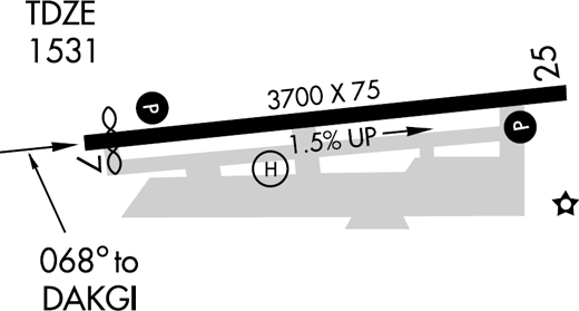
| FAA Airport Diagram |
| IATA: AUN – ICAO: KAUN – FAA LID: AUN |
| Summary |
| Airport type |
Public |
| Owner/Operator |
City of Auburn |
| Serves |
Auburn, California |
| Location |
3 mi (5 km) North of downtown |
| Elevation AMSL |
1,536 ft / 468 m |
| Coordinates |
38°57′17″N 121°04′54″W / 38.95472°N 121.08167°W / 38.95472; -121.08167 |
| Website |
www.auburn.ca.gov/... |
| Runways |
| Direction |
Length |
Surface |
| ft |
m |
| 7/25 |
3,700 |
1,128 |
Asphalt |
| Statistics (2009) |
| Hangars |
81 |
| Permanent Tie-Downs |
112 |
| Transient Tie-Downs |
18 |
| Auburn Municipal Airport, |
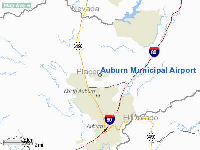
Auburn Municipal Airport (IATA: AUN, ICAO: KAUN, FAA LID: AUN) is a public airport located three miles (5 km) north of Auburn, serving Placer County, California, USA. The airport is mostly used for general aviation.
The City of Auburn owns and operates the airport. The federal government built the airport in 1934 and used it to support mail service until 1946. In 1947, local residents worked to transfer the airport to the city from the federal government and private land owners.
Services include air ambulance, aviation fuel, flight instruction, private charters & rentals, repairs & maintenance, a restaurant, and scenic tours. Private businesses provide these services.
On 30 August 2009, a wildfire named the 49 Fire started southwest of the airport and spread north and east. The fire forced officials to close the airport for a couple days. The fire burned 343 acres (1.39 km) including the airport's western portion (right up to the runway).
Facilities
Auburn Municipal Airport covers 285 acres (115 ha) and has one runway:
- Runway 7/25: 3,700 x 75 ft (1,128 x 23 m) plus 240 ft (73 m) overruns at each end, Surface: Asphalt
The City owns 285 acres (115 ha) around the airport. The airport occupies 205 acres (83 ha). An industrial park fills the remaining 80 acres (32 ha).
- FBO: Mach 5 Aviation, Inc. AKA: "The Pilot Clubhouse!"
- 2409 Rickenbacker Way, Auburn, CA 95602
- (530) 889-2000
- Provides Aircraft Maintenance and Flight Training
The above content comes from Wikipedia and is published under free licenses – click here to read more.

Location
& QuickFacts
|
FAA
Information Effective: |
2006-06-08 |
|
Airport
Identifier: |
AUN |
|
Longitude/Latitude: |
121-04-54.2130W/38-57-17.3450N
-121.081726/38.954818 (Estimated) |
|
Elevation: |
1536 ft / 468.17 m (Surveyed) |
|
Land: |
165 acres |
|
From
nearest city: |
3 nautical miles N of Auburn, CA |
|
Location: |
Placer County, CA |
|
Magnetic Variation: |
16E (1995) |
Owner
& Manager
|
Ownership: |
Publicly owned |
|
Owner: |
City Of Auburn |
|
Address: |
1225 Lincoln Way
Auburn, CA 95603 |
|
Phone
number: |
916-823-4211 |
|
Manager: |
Jerry Martin |
|
Address: |
2409 Rickenbacker Way
Auburn, CA 95602 |
|
Phone
number: |
530-888-8174
AUBURN CITY HALL. ARPT PHONE 916-823-0744. |
Airport
Operations and Facilities
|
Airport
Use: |
Open to public |
|
Wind
indicator: |
Yes |
|
Segmented
Circle: |
Yes |
|
Control
Tower: |
No |
|
Attendance
Schedule: |
MAY-SEP/ALL/0800-1800,OCT-APR/ALL/0800-1700 |
|
Lighting
Schedule: |
DUSK-DAWN
ACTVT MIRL RY 07/25, PAPI RYS 07 & 25 - CTAF. |
|
Beacon
Color: |
Clear-Green (lighted land airport) |
|
Landing
fee charge: |
No |
|
Sectional
chart: |
San Francisco |
|
Region: |
AWP - Western-Pacific |
|
Traffic
Pattern Alt: |
1000 ft |
|
Boundary
ARTCC: |
ZOA - Oakland |
|
Tie-in
FSS: |
RIU - Rancho Murieta |
|
FSS
on Airport: |
No |
|
FSS
Phone: |
916-354-0161 |
|
FSS
Toll Free: |
1-800-WX-BRIEF |
|
NOTAMs
Facility: |
AUN (NOTAM-d service avaliable) |
|
Federal Agreements: |
NGY |
Airport
Communications
|
CTAF: |
122.700 |
|
Unicom: |
122.700 |
Airport
Services
|
Fuel
available: |
100LL80 A |
|
Airframe
Repair: |
MAJOR |
|
Power
Plant Repair: |
MAJOR |
|
Bottled
Oxygen: |
NONE |
|
Bulk
Oxygen: |
NONE |
|
Runway Information
Runway 07/25
|
Dimension: |
3700 x 75 ft / 1127.8 x 22.9 m |
|
Surface: |
ASPH, Good Condition |
|
Weight
Limit: |
Single wheel: 30000 lbs. |
|
Edge
Lights: |
Medium |
|
|
Runway 07 |
Runway 25 |
|
Longitude: |
121-05-17.5100W |
121-04-30.9200W |
|
Latitude: |
38-57-15.4600N |
38-57-19.2300N |
|
Elevation: |
1490.00 ft |
1536.00 ft |
|
Alignment: |
84 |
127 |
|
Traffic
Pattern: |
Left |
Left |
|
Markings: |
Non-precision instrument, Good Condition |
Basic, Good Condition |
|
Crossing
Height: |
0.00 ft |
34.00 ft |
|
Displaced
threshold: |
200.00 ft |
0.00 ft |
|
VASI: |
2-light PAPI on left side |
2-light PAPI on left side |
|
Visual
Glide Angle: |
3.00� |
3.00� |
|
Runway
End Identifier: |
No |
No |
|
Centerline
Lights: |
No |
No |
|
Touchdown
Lights: |
No |
No |
|
Obstruction: |
4 ft hill, 342.0 ft from runway, 35:1 slope
to clear |
10 ft hill, 425.0 ft from runway, 90 ft left
of centerline, 22:1 slope to clear |
|
Radio Navigation
Aids
|
ID |
Type |
Name |
Ch |
Freq |
Var |
Dist |
|
MY |
NDB |
Halow |
|
222.00 |
16E |
27.8 nm |
|
OVE |
NDB |
Oroville |
|
212.00 |
16E |
41.1 nm |
|
BAB |
TACAN |
Beale |
023X |
|
16E |
19.9 nm |
|
HNW |
VOR/DME |
Hangtown |
102X |
115.50 |
17E |
20.8 nm |
|
MCC |
VOR/DME |
Mc Clellan |
029X |
109.20 |
17E |
22.9 nm |
|
MYV |
VOR/DME |
Marysville |
045X |
110.80 |
16E |
24.5 nm |
|
SWR |
VOR/DME |
Squaw Valley |
079X |
113.20 |
16E |
40.3 nm |
|
SAC |
VORTAC |
Sacramento |
099X |
115.20 |
17E |
37.8 nm |
|
ILA |
VORTAC |
Williams |
091X |
114.40 |
18E |
44.7 nm |
|
SMF |
VOT |
Sacramento Metropolitan |
|
111.40 |
|
28.7 nm |
|
SAC |
VOT |
Sacramento Executive |
|
111.40 |
|
32.9 nm |
Remarks
- FUEL
80 AND 100LL AVBL 24 HRS; JET-A AVBL ONLY DURG ARPT OPER HRS.
- NOISE
ABATEMENT PROCEDURE FOR RY 25; AFTER TKOF SPEED & ALT PERMITTING
MAKE 20 DEG LEFT TURN AT END OF RY TO AVOID MOBILE HOME PARK & CONVALESCENT
HOSPITAL.
- RY
07 STRAIGHT OUT DEP IS PREFERRED DEP ROUTE.
- HELICOPTER
TRAFFIC PATTERN 2100 FT MSL (580 FT AGL); RIGHT TRAFFIC FOR RY 07.
- ULTRALIGHT
ACTIVITY ON AND INVOF ARPT.
Based Aircraft
|
Aircraft
based on field: |
212 |
|
Single
Engine Airplanes: |
195 |
|
Multi
Engine Airplanes: |
11 |
|
Helicopters: |
4 |
|
Ultralights: |
2 |
Operational Statistics
|
Aircraft
Operations: |
189/Day |
|
Air Taxi: |
1.6% |
|
General
Aviation Local: |
51.4% |
|
General
Aviation Itinerant: |
47.0% |
Auburn Municipal Airport
Address:
Placer County, CA
Tel:
916-823-4211,
530-888-8174
Images
and information placed above are from
http://www.airport-data.com/airport/AUN/
We
thank them for the data!
| General
Info |
| Country |
United
States |
| State |
CALIFORNIA
|
| FAA ID |
AUN
|
| Latitude |
38-57-17.170N
|
| Longitude |
121-04-55.490W
|
| Elevation |
1531 feet
|
| Near City |
AUBURN
|
We don't guarantee the information is fresh and accurate. The data may
be wrong or outdated.
For more up-to-date information please refer to other sources.
|
 |


