 |
|
Fullerton Municipal Airport |
| Fullerton Municipal Airport |
| IATA: FUL – ICAO: KFUL |
| Summary |
| Airport type |
Public |
| Operator |
City of Fullerton |
| Location |
Fullerton, California |
| Elevation AMSL |
96 ft / 29.3 m |
| Coordinates |
33°52′19.25″N 117°58′47.22″W / 33.8720139°N 117.9797833°W / 33.8720139; -117.9797833 |
| Runways |
| Direction |
Length |
Surface |
| ft |
m |
| 6/24 |
3,121 |
951 |
Asphalt |
| Helipads |
| Number |
Length |
Surface |
| ft |
m |
| H1 |
37 |
11 |
Concrete |
| H2 |
37 |
11 |
Concrete |
| H3 |
37 |
11 |
Concrete |
Fullerton Municipal Airport (IATA: FUL, ICAO: KFUL), owned and operated by the City of Fullerton, is the last strictly general aviation airfield still operating in Orange County, California.
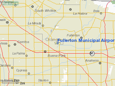
The airport is located in the southwestern corner of Fullerton on Commonwealth Avenue, northeast of the junction of the Santa Ana and Riverside Freeways. The airport and its industrial park are surrounded by residential areas. It is popular among private pilots traveling to nearby attractions such as Disneyland and Knott's Berry Farm. History
Fullerton Municipal Airport can trace its origins back as early as 1913 when barnstormers and crop dusters used the former pig farm as a makeshift landing strip. The site later became home to a sewer farm.
The airport's "official" birthday is 1927. William and Robert Dowling, with the aid of H. A. Krause and the Fullerton Chamber of Commerce, had petitioned the council for permission to turn the by then-abandoned sewer farm into a landing field. The Fullerton City Council approved Ordinance 514 in January 1927, formally establishing the airport. The council leased the land to the chamber for five years, at a fee of $1 per year, and the chamber, in turn, subleased operations to William Dowling and friend Willard Morris of Yorba Linda. The city would assume direct control of the facility in January 1941.
A portion of the Howard Hughes feature Hell's Angels was filmed at Fullerton in 1929. Hughes would feature later in Fullerton's history by buying a tract of land for Hughes Aircraft. The campus eventually became home to Hughes Aircraft Ground Systems Group, closing in 2000.
In 1949, Dick Riedel and Bill Barris of Fullerton Air Service, sponsored by the Fullerton Chamber of Commerce, set a world flight endurance record from the airport, keeping their modified Aeronca Sedan, the Sunkist Lady aloft for 1,008 hours and 2 minutes.
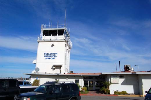
The control tower, built with Federal Aviation Administration funds in 1959, was the first in Orange County.
The California Highway Patrol, Anaheim Police Department, and Orange County Fire Authority maintain helicopters on the airfield.
Facilities
 | |
Fullerton Municipal Airport tower |
Fullerton Municipal Airport covers 86 acres (350,000 m) and has one runway and three heliports:
- Runway 6/24: 3,121 × 75 ft (951 × 23 m), Surface: Asphalt
- Heliport H1: 37 × 37 ft (11 × 11 m), Surface: Concrete
- Heliport H2: 37 × 37 ft (11 × 11 m), Surface: Concrete
- Heliport H3: 37 × 37 ft (11 × 11 m), Surface: Concrete
Its control tower handles an average of 262 flight operations per day.
Accidents and incidents
The airport and surrounding areas have seen their share of aircraft accidents. Residents have complained that pilots often deviate from their mandated approach to the airport, following the BNSF Railway tracks. Pilots, in turn, complain that Fullerton and the neighboring city of Buena Park have permitted too much dense residential development in the area, which had been almost entirely agricultural when the airport was first constructed.
Since 1986, no fewer than 28 planes have crashed at or near the airport, killing a total of 11. Most recently, four were injured on September 27, 2004 when a 1986 replica of a Ford Tri-Motor crashed during an airport day.
The above content comes from Wikipedia and is published under free licenses – click here to read more.

Location
& QuickFacts
|
FAA
Information Effective: |
2006-06-08 |
|
Airport
Identifier: |
FUL |
|
Longitude/Latitude: |
117-58-47.2230W/33-52-19.2510N
-117.979784/33.872014 (Estimated) |
|
Elevation: |
96 ft / 29.26 m (Surveyed) |
|
Land: |
86 acres |
|
From
nearest city: |
3 nautical miles W of Fullerton, CA |
|
Location: |
Orange County, CA |
|
Magnetic Variation: |
14E (1985) |
Owner
& Manager
|
Ownership: |
Publicly owned |
|
Owner: |
City Of Fullerton |
|
Address: |
303 W. Commonwealth Ave
Fullerton, CA 92832 |
|
Phone
number: |
714-738-6310 |
|
Manager: |
Rod Propst |
|
Address: |
4011 W Commonwealth Ave
Fullerton, CA 92633-2594 |
|
Phone number: |
714-738-6323 |
Airport
Operations and Facilities
|
Airport
Use: |
Open to public |
|
Wind
indicator: |
Yes |
|
Segmented
Circle: |
Yes |
|
Control
Tower: |
Yes |
|
Attendance
Schedule: |
ALL/ALL/0600-2200 |
|
Lighting
Schedule: |
DUSK-DAWN
WHEN ATCT CLSD ACTVT MIRL RY 06/24, REIL RYS 06 & 24,
PVASI RY 06, MALSR RY 24 AND TWY LGTS - CTAF. |
|
Beacon
Color: |
Clear-Green (lighted land airport) |
|
Landing
fee charge: |
No |
|
Sectional
chart: |
Los Angeles |
|
Region: |
AWP - Western-Pacific |
|
Traffic
Pattern Alt: |
1004 ft |
|
Boundary
ARTCC: |
ZLA - Los Angeles |
|
Tie-in
FSS: |
RAL - Riverside |
|
FSS
on Airport: |
No |
|
FSS
Phone: |
951-351-3020 |
|
FSS
Toll Free: |
1-800-WX-BRIEF |
|
NOTAMs
Facility: |
FUL (NOTAM-d service avaliable) |
|
Federal Agreements: |
NGY |
Airport
Communications
|
CTAF: |
119.100 |
|
Unicom: |
122.950 |
Airport
Services
|
Fuel
available: |
100LLA |
|
Airframe
Repair: |
MAJOR |
|
Power
Plant Repair: |
MAJOR |
|
Bottled
Oxygen: |
HIGH |
|
Bulk
Oxygen: |
HIGH |
|
Runway Information
Runway 06/24
|
Dimension: |
3121 x 75 ft / 951.3 x 22.9 m |
|
Surface: |
ASPH, Good Condition |
|
Weight
Limit: |
Single wheel: 12500 lbs. |
|
Edge
Lights: |
Medium |
|
|
Runway 06 |
Runway 24 |
|
Longitude: |
117-59-05.3000W |
117-58-29.2410W |
|
Latitude: |
33-52-15.8070N |
33-52-22.7600N |
|
Elevation: |
85.00 ft |
96.00 ft |
|
Alignment: |
77 |
127 |
|
ILS
Type: |
|
LOC/DME
|
|
Traffic
Pattern: |
Left |
Right |
|
Markings: |
Basic, Good Condition |
Non-precision instrument, Good Condition |
|
Crossing
Height: |
23.00 ft |
33.00 ft |
|
Displaced
threshold: |
427.00 ft |
253.00 ft |
|
VASI: |
pulsating/steady burning on left side |
2-box on left side |
|
Visual
Glide Angle: |
4.00� |
4.00� |
|
Approach
lights: |
|
MALSR |
|
Runway
End Identifier: |
Yes |
Yes |
|
Centerline
Lights: |
No |
No |
|
Touchdown
Lights: |
No |
No |
|
Obstruction: |
84 ft tree, 750.0 ft from runway, 220 ft left
of centerline, 6:1 slope to clear
APCH RATIO 14:1 TO DSPLCD THR.
+8 FT FENCE AT 55 FT & +15 FT STREET AT 65 FT FM APCH
END RY 06. |
55 ft tree, 581.0 ft from runway, 208 ft left
of centerline, 7:1 slope to clear
APCH RATIO 15:1 TO DSPLCD THR.
+8 FT FENCE AT 15 FT & +15 FT STREET AT 17 FT; POLE &
RR AT 100 FT FM APCH END RY 24. |
|
Helipad H1
|
Dimension: |
37 x 37 ft / 11.3 x 11.3 m |
|
Surface: |
CONC, |
|
|
Runway H1 |
Runway |
|
Traffic
Pattern: |
Left |
Left |
|
Helipad H2
|
Dimension: |
37 x 37 ft / 11.3 x 11.3 m |
|
Surface: |
CONC, |
|
|
Runway H2 |
Runway |
|
Traffic
Pattern: |
Left |
Left |
|
Helipad H3
|
Dimension: |
37 x 37 ft / 11.3 x 11.3 m |
|
Surface: |
CONC, |
|
|
Runway H3 |
Runway |
|
Traffic
Pattern: |
Left |
Left |
|
Radio Navigation
Aids
|
ID |
Type |
Name |
Ch |
Freq |
Var |
Dist |
|
EMT |
NDB |
El Monte |
|
359.00 |
15E |
13.3 nm |
|
CPM |
NDB |
Compton |
|
378.00 |
15E |
13.4 nm |
|
PAI |
NDB |
Pacoima |
|
370.00 |
15E |
31.8 nm |
|
SB |
NDB |
Petis |
|
397.00 |
14E |
32.5 nm |
|
SJY |
NDB |
San Jacinto |
|
227.00 |
14E |
49.2 nm |
|
RIV |
TACAN |
March |
077X |
|
14E |
35.3 nm |
|
NFG |
TACAN |
Camp Pendleton |
055X |
|
13E |
46.6 nm |
|
RAL |
VOR |
Riverside |
|
112.40 |
15E |
26.9 nm |
|
HDF |
VOR |
Homeland |
|
113.40 |
14E |
40.1 nm |
|
ELB |
VOR/DME |
El Toro |
119X |
117.20 |
14E |
17.1 nm |
|
SMO |
VOR/DME |
Santa Monica |
045X |
110.80 |
15E |
25.2 nm |
|
VNY |
VOR/DME |
Van Nuys |
078X |
113.10 |
15E |
33.1 nm |
|
SLI |
VORTAC |
Seal Beach |
104X |
115.70 |
15E |
6.5 nm |
|
POM |
VORTAC |
Pomona |
041X |
110.40 |
15E |
15.7 nm |
|
PDZ |
VORTAC |
Paradise |
059X |
112.20 |
15E |
22.6 nm |
|
LAX |
VORTAC |
Los Angeles |
083X |
113.60 |
15E |
22.9 nm |
|
SXC |
VORTAC |
Santa Catalina |
051X |
111.40 |
15E |
37.1 nm |
|
PMD |
VORTAC |
Palmdale |
092X |
114.50 |
15E |
45.8 nm |
|
OCN |
VORTAC |
Oceanside |
100X |
115.30 |
15E |
47.3 nm |
|
SNA |
VOT |
Santa Ana |
|
110.00 |
|
13.0 nm |
|
LAX |
VOT |
San Pedro Hill |
|
113.90 |
|
19.3 nm |
Remarks
- ARPT
HAS NOISE ABATEMENT PROCEDURES CTC AMGR (714) 738-6323.
- RY
06 CALM WIND RY.
- LGTD
819' TOWER 2 MILES W-NW OF ARPT.
- PORTIONS
OF TWY A BTN INTERSECTION F & WEST END NOT VSBL FM ATCT.
- FOR
NOISE ABATEMENT RY 06 PREFERRED FOR TKOF; FOLLOW RR TRACKS TO EAST WITH
NO TURNS BLO 1000 FT AGL. RY
24 DEP CLIMB TO 700 FT AGL PRIOR TO TURNS.
- (84)
SEGMENTED CIRCLE LGTD.
Based Aircraft
|
Aircraft
based on field: |
385 |
|
Single
Engine Airplanes: |
341 |
|
Multi
Engine Airplanes: |
34 |
|
Helicopters: |
10 |
Operational Statistics
|
Aircraft
Operations: |
223/Day |
|
Air Taxi: |
0.2% |
|
General
Aviation Local: |
37.7% |
|
General
Aviation Itinerant: |
62.0% |
|
Military: |
0.1% |
Fullerton Municipal Airport
Address:
Orange County, CA
Tel:
714-738-6310,
714-738-6323
Images
and information placed above are from
http://www.airport-data.com/airport/FUL/
We
thank them for the data!
| General
Info |
| Country |
United
States |
| State |
CALIFORNIA
|
| FAA ID |
FUL
|
| Latitude |
33-52-19.251N
|
| Longitude |
117-58-47.223W
|
| Elevation |
96 feet
|
| Near City |
FULLERTON
|
We don't guarantee the information is fresh and accurate. The data may
be wrong or outdated.
For more up-to-date information please refer to other sources.
|
 |


