 |
|
| Lebanon Municipal Airport |
| IATA: LEB – ICAO: KLEB |
| Summary |
| Airport type |
Public |
| Operator |
City of Lebanon |
| Location |
Lebanon, New Hampshire |
| Elevation AMSL |
603 ft / 183.8 m |
| Coordinates |
43°37′34″N 72°18′15″W / 43.62611°N 72.30417°W / 43.62611; -72.30417Coordinates: 43°37′34″N 72°18′15″W / 43.62611°N 72.30417°W / 43.62611; -72.30417 |
| Runways |
| Direction |
Length |
Surface |
| ft |
m |
| 7/25 |
5,496 |
1,675 |
Asphalt |
| 18/36 |
5,200 |
1,585 |
Asphalt |
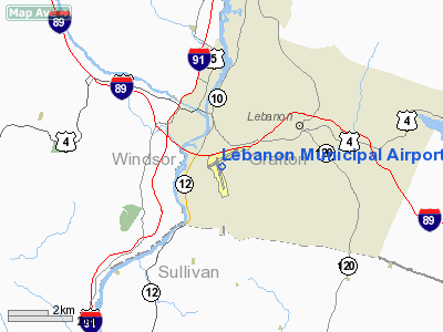
Lebanon Municipal Airport. Lebanon Municipal Airport (IATA: LEB, ICAO: KLEB), also known as Lebanon Airport, is a public airport located in West Lebanon, three miles (5 km) west of the central business district (CBD) of Lebanon, a city in Grafton County, New Hampshire, USA. It is the northernmost commercial airport in New Hampshire, near the Vermont border, off Interstate 89 just south of the junction with Interstate 91. Other nearby towns include Hanover, New Hampshire and White River Junction, Vermont. The area is also the home of Dartmouth College and the Dartmouth-Hitchcock Medical Center. The airport covers 563 acres (228 ha) and has two runways.
 | |
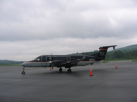
US Airways Express (Colgan Air) Beech 1900D at Lebanon Municipal Airport. |
In recent years, the airport has struggled due to competition with the much larger Manchester-Boston Regional Airport, 65 miles (87 kilometers) away.[1] Colgan Air formerly offered non-stop flights from Lebanon to New York-La Guardia Airport operating as US Airways Express. The airline first operated the flights with the Beechcraft 1900, and later with the Saab 340 before service ended in November 2008.
On November 2, 2008, Cape Air began offering service to Boston. Airline service is subsidized by the Essential Air Service program utilizing the smaller Cessna 402 aircraft. The terminal building has typical facilities such as baggage claim, a check-in desk, rental car services, and airport security.
Airlines and destinations
| Airlines |
Destinations |
| Cape Air |
Boston, White Plains |
The above content comes from Wikipedia and is published under free licenses – click here to read more.

Location & QuickFacts
| FAA Information Effective: | 2008-09-25 |
| Airport Identifier: | LEB |
| Airport Status: | Operational |
| Longitude/Latitude: | 072-18-15.1000W/43-37-34.0000N
-72.304194/43.626111 (Estimated) |
| Elevation: | 603 ft / 183.79 m (Surveyed) |
| Land: | 563 acres |
| From nearest city: | 3 nautical miles W of Lebanon, NH |
| Location: | Grafton County, NH |
| Magnetic Variation: | 16W (1995) |
Owner & Manager
| Ownership: | Publicly owned |
| Owner: | City Of Lebanon |
| Address: | 51 No Park St
Lebanon, NH 03766 |
| Phone number: | 603-448-4220 |
| Manager: | Mr. David Gobin |
| Address: | 5 Airpark Rd, 5 Airpark Rd
West Lebanon, NH 03784 |
| Phone number: | 603-298-8878 |
Airport Operations and Facilities
| Airport Use: | Open to public |
| Wind indicator: | Yes |
| Segmented Circle: | Yes |
| Control Tower: | Yes |
| Lighting Schedule: | DUSK-DAWN
ACTVT MIRL RY 07/25 & HIRL RY 18/36 - CTAF. |
| Beacon Color: | Clear-Green (lighted land airport) |
| Landing fee charge: | Yes
LANDING FEES EXCEPT FOR NON-COMMERCIAL SINGLE ENGINE. |
| Sectional chart: | New York |
| Region: | ANE - New England |
| Boundary ARTCC: | ZBW - Boston |
| Tie-in FSS: | BGR - Bangor |
| FSS on Airport: | No |
| FSS Toll Free: | 1-800-WX-BRIEF |
| NOTAMs Facility: | LEB (NOTAM-d service avaliable) |
| Certification type/date: | I A S 09/1989
24 HR PPR FOR UNSCHEDULED ACR OPNS WITH MORE THAN 30 PSGR SEATS; CALL AMGR 603-298-8878. ARFF IS ONLY AVAILABLE FOR SCHEDULED AIR CARRIER OPERATIONS 15 MINUTES BEFORE OR AFTER THE SCHEDULED ARRIVAL OR DEPARTURE TIMES. PRIOR COORDINATION IS REQUIRED FOR AIR CARRIERS OPERATING OUTSIDE THESE HOURS. |
| Federal Agreements: | NGY3 |
Airport Communications
| CTAF: | 125.950 |
| Unicom: | 122.950 |
Airport Services
| Fuel available: | 100LLA |
| Airframe Repair: | MAJOR |
| Power Plant Repair: | MAJOR |
| Bulk Oxygen: | HIGH |
Runway Information
Runway 07/25
| Dimension: | 5496 x 100 ft / 1675.2 x 30.5 m |
| Surface: | ASPH, Good Condition |
| Surface Treatment: | Saw-cut or plastic Grooved |
| Weight Limit: | Single wheel: 42000 lbs.
Dual wheel: 60000 lbs. |
| Edge Lights: | Medium |
| |
Runway 07 |
Runway 25 |
| Longitude: | 072-18-43.4110W | 072-17-39.1623W |
| Latitude: | 43-37-33.0157N | 43-38-00.7247N |
| Elevation: | 562.00 ft | 574.00 ft |
| Alignment: | 59 | 127 |
| Traffic Pattern: | Left | Left |
| Markings: | Non-precision instrument, Good Condition | Non-precision instrument, Good Condition |
| Crossing Height: | 50.00 ft | 54.00 ft |
| VASI: | 4-light PAPI on left side | 4-box on left side |
| Visual Glide Angle: | 4.00° | 3.80° |
| Runway End Identifier: | Yes | Yes |
| Centerline Lights: | No | No |
| Touchdown Lights: | No | No |
| Obstruction: | 42 ft trees, 950.0 ft from runway, 300 ft right of centerline, 18:1 slope to clear | 100 ft gnd, 400.0 ft from runway, 250 ft left of centerline, 20:1 slope to clear |
|
Runway 18/36
| Dimension: | 5200 x 100 ft / 1585.0 x 30.5 m |
| Surface: | ASPH, Good Condition |
| Surface Treatment: | Saw-cut or plastic Grooved |
| Weight Limit: | Single wheel: 42000 lbs.
Dual wheel: 48000 lbs. |
| Edge Lights: | High |
| |
Runway 18 |
Runway 36 |
| Longitude: | 072-18-26.5092W | 072-18-11.7796W |
| Latitude: | 43-37-45.5103N | 43-36-55.2814N |
| Elevation: | 563.00 ft | 603.00 ft |
| Alignment: | 127 | 127 |
| ILS Type: | ILS/DME
| |
| Traffic Pattern: | Left | Left |
| Markings: | Precision instrument, Good Condition | Precision instrument, Good Condition |
| Crossing Height: | 0.00 ft | 50.00 ft |
| VASI: | | 4-light PAPI on left side |
| Visual Glide Angle: | 0.00° | 3.75° |
| Runway End Identifier: | Yes | No |
| Centerline Lights: | No | No |
| Touchdown Lights: | No | No |
| Obstruction: | , 50:1 slope to clear | 118 ft trees, 2200.0 ft from runway, 500 ft right of centerline, 16:1 slope to clear |
|
Radio Navigation Aids
| ID |
Type |
Name |
Ch |
Freq |
Var |
Dist |
| R | FAN MARKER | Chitt | | | 14W | 29.2 nm |
| LCI | FAN MARKER | Laconia | | | | 37.7 nm |
| MPV | FAN MARKER | Brook | | | | 44.4 nm |
| LAH | NDB | Hanover | | 276.00 | 15W | 7.2 nm |
| IVV | NDB | White River | | 379.00 | 16W | 8.1 nm |
| CNH | NDB | Claremont | | 233.00 | 16W | 15.7 nm |
| SXD | NDB | Springfield | | 265.00 | 15W | 24.7 nm |
| DYO | NDB | Smuto | | 221.00 | 15W | 28.8 nm |
| LC | NDB | Blnap | | 328.00 | 16W | 33.8 nm |
| CO | NDB | Epsom | | 216.00 | 16W | 48.1 nm |
| VWD | NDB | Mount Snow | | 224.00 | 15W | 48.6 nm |
| VKN | NDB | Mount Mansfield | | 268.00 | 16W | 48.7 nm |
| LEB | VOR/DME | Lebanon | 084X | 113.70 | 15W | 5.0 nm |
| MPV | VOR/DME | Montpelier | 045X | 110.80 | 16W | 28.3 nm |
| RUT | VOR/DME | Rutland | 47X | 111.00 | 15W | 28.8 nm |
| CON | VORTAC | Concord | 076X | 112.90 | 15W | 40.1 nm |
Remarks
- TREES 5600 ' E OF ARPT AT 1253'. TREES 6700' E OF ARPT AT 1275'; TREES INDICATED ARE OBSTN LGTD.
- OCNL DEER AND BIRD ACTIVITY ON AND NEAR ARPT.
- HANG GLIDER OPNS VICINITY MT ASCUTNEY VT 20 MI SW LEB SFC-8000 FT DAYS.
- NO PRACTICE LOW APPROACH OR TOUCH & GO LANDING 0000-0700.
- NOISE ABATEMENT PROCS IN EFFECT; CTC AMGR. ALL ARR/DEP ACFT FOLLOW MANUFACTURER'S RCMDD PROC FOR QUIET OPN & MINIMUM NOISE.
- EAST RAMP CLSD.
- ESTAB PRIOR TO 1959.
Images and information placed above are from
http://www.airport-data.com/airport/LEB/
We thank them for the data!
| General Info
|
| Country |
United States
|
| State |
NEW HAMPSHIRE
|
| FAA ID |
LEB
|
| Latitude |
43-37-34.000N
|
| Longitude |
072-18-15.100W
|
| Elevation |
603 feet
|
| Near City |
LEBANON
|
We don't guarantee the information is fresh and accurate. The data may
be wrong or outdated.
For more up-to-date information please refer to other sources.
|
 |


