 |
|
Portsmouth Intl At Pease Airport |
Portsmouth International Airport at Pease
Pease Air National Guard Base |
 |
| IATA: PSM – ICAO: KPSM – FAA LID: PSM |
| Summary |
| Airport type |
Public / Military |
| Owner |
Pease Development Authority |
| Serves |
Portsmouth, New Hampshire |
| Location |
Portsmouth / Newington, New Hampshire, USA |
| Elevation AMSL |
100 ft / 30 m |
| Coordinates |
43°04′41″N 070°49′24″W / 43.07806°N 70.82333°W / 43.07806; -70.82333 |
| Website |
http://www.peasedev.org/pease/airport.asp |
| Runways |
| Direction |
Length |
Surface |
| ft |
m |
| 16/34 |
11,321 |
3,451 |
Asphalt/Concrete |
| Statistics (2007) |
| Aircraft operations |
51,673 |
| Based aircraft |
107 |
| Sources: airport website and FAA |
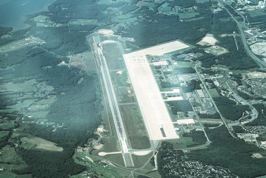
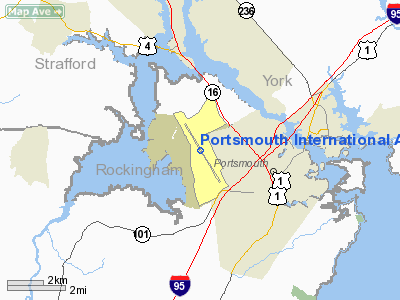
Portsmouth International Airport at Pease (IATA: PSM, ICAO: KPSM, FAA LID: PSM) (formerly known as Pease International Airport) is a public-use joint civil-military airport located one nautical mile (2 km) west of the central business district of Portsmouth, a city in Rockingham County, New Hampshire, United States. It is owned by the Pease Development Authority.
The airport is located within the Pease International Tradeport, a result of the ongoing redevelopment of the former Pease Air Force Base which was closed under Base Realignment and Closure (BRAC) Commission action in the late 1980s and early 1990s.
It shares the runway with the Pease Air National Guard Base, which is actively utilized by the 157th Air Refueling Wing (157 ARW) of the New Hampshire Air National Guard, an Air Mobility Command (AMC)-gained Air National Guard unit operating the KC-135R Stratotanker aircraft.
Pease is one of 7 Launch Abort Sites and one of 18 Emergency Landing Sites for NASA space shuttle orbiters.
The airport does not currently offer scheduled commercial airline service. It served as a hub for Pan Am from 1998 until 2005, when all mainline Pan Am flights at the airport were suspended. It was also one of a handful of airports serviced by the short-lived Skybus Airlines which ceased operation in the spring of 2008.
Facilities and aircraft
Portsmouth International Airport at Pease covers an area of 3,000 acres (1,214 ha) at an elevation of 100 feet (30 m) above mean sea level. It has one concrete and asphalt paved runway designated 16/34 which measures 11,321 by 150 feet (3,451 x 46 m).
For the 12-month period ending October 1, 2007, the airport had 51,673 aircraft operations, an average of 141 per day: 68% general aviation, 22% military, 7% air taxi and 3% scheduled commercial. At that time there were 107 aircraft based at this airport: 52% single-engine, 19% multi-engine, 12% jet, 2% helicopter and 15% military.
The above content comes from Wikipedia and is published under free licenses – click here to read more.
Location & QuickFacts
| FAA Information Effective: | 2008-09-25 |
| Airport Identifier: | PSM |
| Airport Status: | Operational |
| Longitude/Latitude: | 070-49-23.8000W/43-04-40.6000N
-70.823278/43.077944 (Estimated) |
| Elevation: | 100 ft / 30.48 m (Surveyed) |
| Land: | 3000 acres |
| From nearest city: | 1 nautical miles W of Portsmouth, NH |
| Location: | Rockingham County, NH |
| Magnetic Variation: | 16W (2005) |
Owner & Manager
| Ownership: | Publicly owned |
| Owner: | Pease Development Authority |
| Address: | 360 Corporate Avenue
Portsmouth, NH 03801 |
| Phone number: | 603-433-6536 |
| Manager: | Kim W. (bill) Hopper, A.a.e |
| Address: | 36 Airline Dr
Portsmouth, NH 03801 |
| Phone number: | 603-433-6536 |
Airport Operations and Facilities
| Airport Use: | Open to public |
| Wind indicator: | Yes |
| Segmented Circle: | No |
| Control Tower: | Yes |
| Lighting Schedule: | DUSK-DAWN |
| Beacon Color: | Clear-Green (lighted land airport) |
| Landing fee charge: | Yes
LNDG FEE FOR CIVIL TRAN ACFT OVER 12500 LBS. |
| Sectional chart: | New York |
| Region: | ANE - New England |
| Boundary ARTCC: | ZBW - Boston |
| Tie-in FSS: | BGR - Bangor |
| FSS on Airport: | No |
| FSS Toll Free: | 1-800-WX-BRIEF |
| NOTAMs Facility: | PSM (NOTAM-d service avaliable) |
| Certification type/date: | I E S 10/1992 |
| Federal Agreements: | NGPY |
Airport Communications
Airport Services
| Fuel available: | 100LLA
J8 FUEL AVBL AT ANG 603-430-2459. |
| Airframe Repair: | MAJOR |
| Power Plant Repair: | MAJOR |
Runway Information
Runway 16/34
| Dimension: | 11321 x 150 ft / 3450.6 x 45.7 m |
| Surface: | ASPH-CONC, Good Condition
FIRST 1000 FT BOTH ENDS CONC-GRVD; REMAINDER ASPH-GRVD. |
| Surface Treatment: | Saw-cut or plastic Grooved |
| Weight Limit: | Single wheel: 120000 lbs.
Dual wheel: 175000 lbs.
Dual tandem wheel: 175000 lbs.
Dual dual tandem wheel: 549000 lbs. |
| Edge Lights: | High
EDGE LIGHTS ARE 24 INCHES TALL; 85 FT FM CNTRLN. |
| |
Runway 16 |
Runway 34 |
| Longitude: | 070-50-02.9997W | 070-48-44.6011W |
| Latitude: | 43-05-28.6003N | 43-03-52.6772N |
| Elevation: | 94.00 ft | 84.00 ft |
| Alignment: | 127 | 127 |
| ILS Type: | ILS
| ILS
|
| Traffic Pattern: | Right | Left |
| Markings: | Precision instrument, Good Condition
16/34 DOUBLE FACED DISTANCE MARKERS BOTH SIDES OF RY AT 1000 FT INTERVALS. | Precision instrument, Good Condition |
| Crossing Height: | 55.00 ft | 64.00 ft |
| Displaced threshold: | 803.00 ft | 0.00 ft |
| VASI: | 4-light PAPI on left side | 4-light PAPI on left side |
| Visual Glide Angle: | 3.00° | 3.00° |
| RVR Equipment: | touchdown | touchdown |
| Approach lights: | MALSR | MALSR |
| Obstruction: | 58 ft trees, 2200.0 ft from runway, 34:1 slope to clear
50:1 TO DISPLACED THRESHOLD. | , 50:1 slope to clear |
|
Radio Navigation Aids
| ID |
Type |
Name |
Ch |
Freq |
Var |
Dist |
| BVY | FAN MARKER | Beverly | | | | 28.6 nm |
| LCI | FAN MARKER | Laconia | | | | 39.9 nm |
| PH | MARINE NDB | Portland Lhb-p | | 301.00 | 17W | 41.9 nm |
| ESG | NDB | Rollins | | 260.00 | 16W | 8.5 nm |
| CO | NDB | Epsom | | 216.00 | 16W | 27.7 nm |
| DRY | NDB | Derry | | 338.00 | 16W | 28.2 nm |
| TOF | NDB | Topsfield | | 269.00 | 16W | 28.2 nm |
| AS | NDB | Chern | | 359.00 | 16W | 37.5 nm |
| LQ | NDB | Lyndy | | 382.00 | 16W | 38.1 nm |
| SKR | NDB | Shaker Hill | | 251.00 | 16W | 40.6 nm |
| LC | NDB | Blnap | | 328.00 | 16W | 41.7 nm |
| SZO | NDB | Sebago | | 227.00 | 17W | 49.7 nm |
| PSM | VOR/DME | Pease | 112X | 116.50 | 16W | 0.5 nm |
| LWM | VOR/DME | Lawrence | 072X | 112.50 | 15W | 23.5 nm |
| MHT | VOR/DME | Manchester | 091X | 114.40 | 15W | 27.1 nm |
| ENE | VORTAC | Kennebunk | 118X | 117.10 | 17W | 22.8 nm |
| CON | VORTAC | Concord | 076X | 112.90 | 15W | 34.1 nm |
| BOS | VORTAC | Boston | 074X | 112.70 | 16W | 43.9 nm |
| PWM | VOT | Portland Intl Jetport | | 111.00 | | 40.5 nm |
| BED | VOT | Laurence G Hanscom Fld | | 110.00 | | 42.0 nm |
| BOS | VOT | Boston Logan Intl | | 111.00 | | 43.0 nm |
Remarks
- ON DEP MAINTAIN RY HEADING TO 1100 FT MSL OR THE END OF THE RY (WHICHEVER OCCURS LAST) PRIOR TO TURNING.
- 1000 FT BY 200 FT PAVED OVRN EACH END OF RY 16/34.
- LITTLEBROOK AIRPARK LCTD 052 DEG 4.4 NM; TFC PATTERN 1130 FT MSL. FLY DOWNWIND LEG NO CLOSER THAN 1/2 MI FM RY.
- NO 180 DEG TURNS FOR ACFT OVER 12500 LBS GWT ON ASPH PORTION OF RY 16/34.
- CUSTOMS OFC HRS MON THRU FRI 0900-1630, EXCLUDING HOLS. CUSTOMS MUST BE ARRANGED 0900-1630 MON-FRI (EXCP HOLS) AT 603-422-0910.INT'L ARRIVALS MUST ARRANGE FOR GROUND HANDLING PRIOR TO ARRIVAL. FBO-603-427-0350/122.95 OR 603-433-1111/128.825.
- RY 34 IS PREFERRED WHEN TALL WIND COMPONENT IS LESS THAN FIVE KNOTS. RY 16 IS PREFERRED FOR TKF, BETWEEN 2200-0659, WHEN TALL WIND COMPONENT IS FIVE KNOTS OR LESS.
- ALL INBND ACFT WITH HAZARDOUS CARGO INFO CALL ATCT 60 NM OUT.
- PEASE OPERATES UNDER BASH PHASE 1 YEAR ROUND.
- CAUTION: HEIGHT GROUP 1 WCH 54 FT.
- ANG: PPR CTC COMD POST, DSN 852-2459, C603-430-2459. NETTF - PPR CTC TANKER TASK FORCE (TTF) DSN 852-3485, C603-430-3485. ACFT TRANS THE NHANG RAMP OR ON AN AMC MSN, CTC ANG OPS (PACK CONTROL) 20 MIN PRIOR TO LDG. LTD PAX SVC W/O COORD. FBO WITH MIL CONTRACT AVBL 1-888-732-7324.
- TURBULENCE APCH END RY 34 IN STRONG CROSS WINDS.
- NO PRACTICE LOW APCH OR TGL 2300-0700 FOR LOCAL-BASED ACFT & 2100-0700 FOR TRANSIENT ACFT OR BEFORE 1200 SUN FOR ALL ACFT.
- BIRDS ON AND INVOF ARPT.
- NOISE SENSITIVE AREAS OFF BOTH ENDS RY.
- TFC PAT: RECTANGULAR 1600 FT MSL OVERHEAD 2100 FT MSL - LIGHT ACFT 1100 FT MSL.
- ON OTHER THAN A PUBLISHED IAP--ARRIVING ACFT SHOULD ESTABLISH THEMSELVES ON FINAL APCH AT LEAST 2 NM FROM THE RY THR AT A MIN OF 700 FT MSL.
- AVOID CLOSE IN BASE LEGS/SHORT APCHS.
Images and information placed above are from
http://www.airport-data.com/airport/PSM/
We thank them for the data!
| General Info
|
| Country |
United States
|
| State |
NEW HAMPSHIRE
|
| FAA ID |
PSM
|
| Latitude |
43-04-40.652N
|
| Longitude |
070-49-23.784W
|
| Elevation |
100 feet
|
| Near City |
PORTSMOUTH
|
We don't guarantee the information is fresh and accurate. The data may
be wrong or outdated.
For more up-to-date information please refer to other sources.
|
|


