 |
|
McNary Field
Salem Municipal Airport |
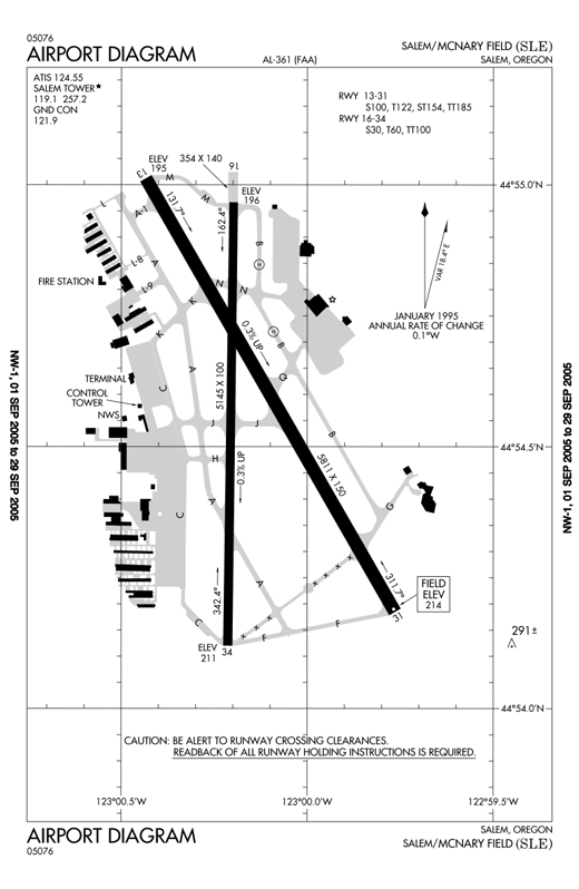 |
| FAA diagram of McNary Field |
| IATA: SLE – ICAO: KSLE – FAA LID: SLE |
| Summary |
| Airport type |
Public |
| Owner |
City of Salem |
| Location |
Salem, Oregon |
| Elevation AMSL |
214 ft / 65 m |
| Coordinates |
44°54′34″N 123°00′09″W / 44.90944°N 123.0025°W / 44.90944; -123.0025 |
| Website |
www.cityofsalem.net/airport/ |
| Runways |
| Direction |
Length |
Surface |
| ft |
m |
| 13/31 |
5,811 |
1,771 |
Asphalt/grooved |
| 16/34 |
5,145 |
1,568 |
Asphalt/grooved |
| Statistics (2003) |
| Aircraft operations |
50,282 |
| Based aircraft |
232 |
| Source: Federal Aviation Administration |
McNary Field (IATA: SLE, ICAO: KSLE, FAA LID: SLE), also known as Salem Municipal Airport, is a public airport located two miles (3 km) southeast of the central business district of Salem, a city in Marion County, Oregon, United States, also the capital of the state. The airport is named for Senator Charles L. McNary. This airport is publicly owned by City of Salem.
Primarily a general aviation airport, McNary Field has seen scheduled commercial airline service in the past, and recently had scheduled air carrier service via Delta Air Lines (service ended October 2008). The Oregon Army National Guard - Army Aviation Support Facility (AASF) and charter flights also use the facilities. McNary Field serves as the home of the Oregon Department of Aviation. Airline service
The city of Salem has actively campaigned to bring the airlines back to McNary Field, which had no airline service at all since 1993. Even then, there was only a once a day flight to Portland. The last time Salem had airline service of any distance was in the early 1980s. At that time, United airlines flew from Salem to San Francisco using Boeing 737s. On June 7, 2007, Delta Connection returned commercial air service to Salem with two flights a day in each direction to Salt Lake City. On October 9, 2008, the last Delta flight left McNary as the service ended.
Facilities and aircraft
McNary Field covers an area of 751 acres (304 ha) and has two runways: 13/31, which is 5,811 ft (1,771 m) and ILS equipped, and a visual approach 5,145 ft (1,568 m) runway (16/34). The airport grounds include a control tower, a restaurant, a general aviation center including limited flight training, and a small terminal building. On the east side of the airport is Garmin Aviation, maker of aviation GPS units.
For 12-month period ending 02/28/2003 the airport had 50,282 aircraft operations, an average of 137 per day:
- 92% general aviation: 46,059
- 5% military: 2,672
- 3% air taxi: 1,551
There are 232 aircraft based at this airport:
- 77% single engine: 178
- 10% multi engine: 23
- 9% military: 22
- 2% jet aircraft: 4
- 2% helicopters: 4
- <1% gliders: 1
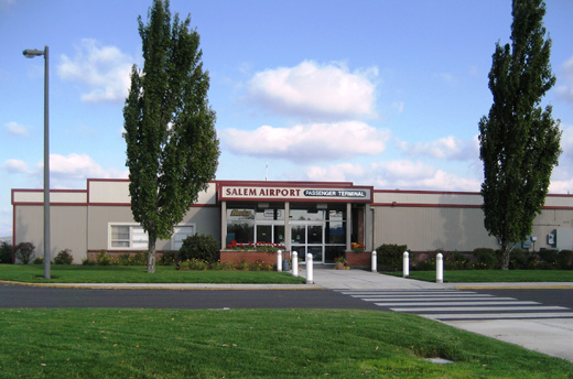 | |
Terminal building |
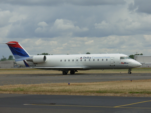 | |
Delta Connection operated by SkyWest Airlines served the airport from June 2007 to October 2008 |
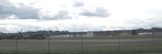 | |
Oregon National Guard helicopters at McNary Field |
Cargo carriers
- Federal Express
- United Parcel Service
The above content comes from Wikipedia and is published under free licenses – click here to read more.
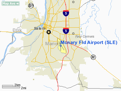
Location & QuickFacts
| FAA Information Effective: | 2008-09-25 |
| Airport Identifier: | SLE |
| Airport Status: | Operational |
| Longitude/Latitude: | 123-00-09.0000W/44-54-34.3000N
-123.002500/44.909528 (Estimated) |
| Elevation: | 214 ft / 65.23 m (Surveyed) |
| Land: | 751 acres |
| From nearest city: | 2 nautical miles SE of Salem, OR |
| Location: | Marion County, OR |
| Magnetic Variation: | 17E (2005) |
Owner & Manager
| Ownership: | Publicly owned |
| Owner: | City Of Salem |
| Address: | 555 Liberty St Rm 305
Salem, OR 97302 |
| Phone number: | 503-588-6314 |
| Manager: | Alan Alexander |
| Address: | 2990 25th St Se
Salem, OR 97302 |
| Phone number: | 503-589-2057 |
Airport Operations and Facilities
| Airport Use: | Open to public |
| Wind indicator: | Yes |
| Segmented Circle: | Yes |
| Control Tower: | Yes |
| Lighting Schedule: | DUSK-DAWN
WHEN ATCT CLSD ACTVT HIRL RY 13/31; MIRL RY 16/34; REILS RY 13, RY 16 AND RY34; MALSR RY 31 & ODALS RY 13 - CTAF. |
| Beacon Color: | Clear-Green (lighted land airport) |
| Landing fee charge: | No |
| Sectional chart: | Seattle |
| Region: | ANM - Northwest Mountain |
| Boundary ARTCC: | ZSE - Seattle |
| Tie-in FSS: | MMV - Mc Minnville |
| FSS on Airport: | No |
| FSS Toll Free: | 1-800-WX-BRIEF |
| NOTAMs Facility: | SLE (NOTAM-d service avaliable) |
| Certification type/date: | I A U 05/1973
PPR FOR UNSKED ACR OPNS WITH MORE THAN 30 PSGR SEATS CALL AMGR ON 503-588-6314. |
| Federal Agreements: | NGPY3 |
Airport Communications
| CTAF: | 119.100 |
| Unicom: | 122.950 |
Airport Services
| Fuel available: | 100LLA |
| Airframe Repair: | MAJOR |
| Power Plant Repair: | MAJOR |
| Bottled Oxygen: | HIGH |
| Bulk Oxygen: | HIGH |
Runway Information
Runway 13/31
| Dimension: | 5811 x 150 ft / 1771.2 x 45.7 m |
| Surface: | ASPH, Good Condition |
| Surface Treatment: | Saw-cut or plastic Grooved |
| Weight Limit: | Single wheel: 100000 lbs.
Dual wheel: 122000 lbs.
Dual tandem wheel: 185000 lbs. |
| Edge Lights: | High |
| |
Runway 13 |
Runway 31 |
| Longitude: | 123-00-26.1169W | 122-59-45.8566W |
| Latitude: | 44-55-00.7371N | 44-54-11.0077N |
| Elevation: | 195.00 ft | 214.00 ft |
| Alignment: | 127 | 127 |
| ILS Type: | | ILS/DME
|
| Traffic Pattern: | Left | Left |
| Markings: | Non-precision instrument, Good Condition | Precision instrument, Good Condition |
| Crossing Height: | 51.00 ft | 0.00 ft |
| VASI: | 4-box on left side | |
| Visual Glide Angle: | 3.00° | 0.00° |
| RVR Equipment: | | touchdown |
| Approach lights: | ODALS | MALSR |
| Runway End Identifier: | Yes | |
| Obstruction: | 11 ft road, 600.0 ft from runway, 550 ft right of centerline, 36:1 slope to clear | 459 ft tree, 15950.0 ft from runway, 1900 ft left of centerline, 30:1 slope to clear |
|
Runway 16/34
| Dimension: | 5145 x 100 ft / 1568.2 x 30.5 m |
| Surface: | ASPH, Good Condition |
| Surface Treatment: | Saw-cut or plastic Grooved |
| Weight Limit: | Single wheel: 30000 lbs.
Dual wheel: 60000 lbs.
Dual tandem wheel: 100000 lbs. |
| Edge Lights: | Medium |
| |
Runway 16 |
Runway 34 |
| Longitude: | 123-00-11.8945W | 123-00-12.8586W |
| Latitude: | 44-54-57.9935N | 44-54-07.1985N |
| Elevation: | 196.00 ft | 211.00 ft |
| Alignment: | 127 | 1 |
| Traffic Pattern: | Left | Left |
| Markings: | Non-precision instrument, Good Condition | Non-precision instrument, Good Condition |
| Crossing Height: | 40.00 ft | 44.00 ft |
| VASI: | 4-light PAPI on left side | 4-light PAPI on left side |
| Visual Glide Angle: | 3.00° | 4.00° |
| Runway End Identifier: | Yes | Yes |
| Obstruction: | 16 ft road, 430.0 ft from runway, 280 ft left of centerline, 14:1 slope to clear | 216 ft tree, 4528.0 ft from runway, 273 ft right of centerline, 20:1 slope to clear |
|
Radio Navigation Aids
| ID |
Type |
Name |
Ch |
Freq |
Var |
Dist |
| LWG | NDB | Lewisburg | | 225.00 | 18E | 21.2 nm |
| EU | NDB | Frakk | | 260.00 | 19E | 42.9 nm |
| PND | NDB | Banks | | 356.00 | 21E | 43.4 nm |
| LBH | NDB | Laker | | 332.00 | 20E | 44.3 nm |
| CBU | TACAN | Columbia | 029X | | 20E | 44.0 nm |
| UBG | VOR/DME | Newberg | 121X | 117.40 | 21E | 26.7 nm |
| CVO | VOR/DME | Corvallis | 101X | 115.40 | 18E | 27.6 nm |
| PDX | VOR/DME | Portland | 055X | 111.80 | 20E | 44.4 nm |
| EUG | VORTAC | Eugene | 076X | 112.90 | 20E | 48.3 nm |
| ONP | VORTAC | Newport | 118X | 117.10 | 19E | 49.4 nm |
| HIO | VOT | Portland-hillsboro | | 115.20 | | 38.0 nm |
| PDX | VOT | Portland Intl | | 111.00 | | 44.7 nm |
Remarks
- BIRD HAZARD: HVY CONCENTRATION WATERFOWL ADJ TO APT & APCHS TO ALL RYS. FLOCKS OF GEESE CONCENTRATED TRANSITING CLASS D AIRSPACE AT TPA OCT-MAY.
- TWY 'A' FM TWY 'L' TO 'L9' NOT VISIBLE FM ATCT.
- SELF-FUELING (100LL ONLY) AVBL 24 HOURS A DAY. JET A AVBL AFTER NORMAL BUSINESS HRS WITH ADVANCED NOTICE AT 503-508-4178 OR 503-364-0111.
- REMARKS: ARNG OPR 1500-0030Z++.
- PPR REQUIRED FOR PARKING ACFT ON G/A RAMP OVER 99,000 LBS CALL AMGR 503-588-6314.
- ESTBD PRIOR TO 1959.
Images and information placed above are from
http://www.airport-data.com/airport/SLE/
We thank them for the data!
| General Info
|
| Country |
United States
|
| State |
OREGON
|
| FAA ID |
SLE
|
| Latitude |
44-54-34.300N
|
| Longitude |
123-00-09.000W
|
| Elevation |
214 feet
|
| Near City |
SALEM
|
We don't guarantee the information is fresh and accurate. The data may
be wrong or outdated.
For more up-to-date information please refer to other sources.
|
 |


