|
 |
|
||||
|
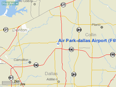
Air Park-Dallas Airport (FAA LID: F69) is a public airport located 16 nautical miles (30 km) northwest of the central business district of Dallas, in Collin County, Texas, United States. The airport is used solely for general aviation purposes. FacilitiesAir Park-Dallas Airport has one runway:
Air Park-Dallas has been the subject of much litigation. See In re Crow-Billingsley Air Park, Ltd., 98 S.W.3d 178 (Tex. 2003); Noell v. Air Park Homeowners Assoc., Inc., 246 S.W.3d 827 (Tex. App. - Dallas 2008, pet. denied); Noell v. Crow-Billingsley Air Park, Ltd., 233 S.W.3d 408 (Tex. App. - Dallas 2007, pet. denied); Air Park-Dallas Zoning Committee v. Crow-Billingsley Air Park, Ltd., 109 S.W.3d 900 (Tex. App. - Dallas 2003, no pet.); Harrison v. Air Park Estates Zoning Committee, 533 S.W.2d 108 (Tex. Civ. App. - Dallas 1976, no writ). On February 5, 2008, the City of Carrollton adopted an ordinance annexing much of the runway tract into the city. The annexation was carefully crafted such that the City of Carrollton could enact ordinances to regulate the airpark's operations, while carving the residential areas at the field out from the annexed area, thus avoiding any obligation to provide basic city services (such as police, fire or sewer services) to the residents. Four days after the annexation, a single-engine Piper PA-28-140 aircraft (N4998L) crashed just south of the runway while attempting to land at Air Park. The NTSB investigated and found pilot error to blame (see DFW08CA067). On July 15, 1995, a single-engine Beech C35 aircraft (N1997D) crashed just north of the runway while attempting to land at Air Park. The NTSB investigated and found pilot error to blame (see FTW95FA300). On August 10, 2008, a single-engine Mooney M-20-E aircraft (N1334W) made a gear up landing on Runway 16 at Air Park. According to the FAA's Accident and Incident Database (Report No. 20080810848979G), the aircraft was removed from the runway prior to the arrival of an NTSB investigator, thus eliminating the hazard represented by the presence of the disabled aircraft on the runway. Because a gear-up landing on a runway is not considered an "accident" by the NTSB, NTSB accident investigators do not routinely visit the site of gear-up landings. On November 25, 2008, the City of Carrollton adopted Ordinance No. 3267, which amended Chapter 92 ("Nuisances") of the Carrollton Code of Ordinances by adding provisions to regulate privately-owned public access airports. The new ordinance took effect January 2, 2009. On January 23, 2009, less than three weeks after the effective date of the new Carrollton ordinance, a single-engine Cessna 172E aircraft (N5420T) made an off-airport landing at the Prestonwood Country Club Golf Course just north of the runway after experiencing a loss of engine power while en route to Air Park. The NTSB investigated and found that the loss of engine power was due to fuel exhaustion resulting from the pilot's inadequate fuel planning (see CEN09LA143). The above content comes from Wikipedia and is published under free licenses – click here to read more.
Location & QuickFacts
Owner & Manager
Airport Operations and Facilities
Airport Communications
Airport Services
Runway InformationRunway 16/34
Radio Navigation Aids
Remarks
Images and information placed above are from We thank them for the data!
We don't guarantee the information is fresh and accurate. The data may
be wrong or outdated.
|
|||||||||||||||||||||||||||||||||||||||||||||||||||||||||||||||||||||||||||||||||||||||||||||||||||||||||||||||||||||||||||||||||||||||||||||||||||||||||||||||||||||||||||||||||||||||||||||||||||||||||||||||||||||||||||||||||||||||||||||||||||||||||||||||||||||||||||||||||||||||||||||||||||||||||||||||||||||||||||||||||||||

 |
|
Copyright 2004-2026 © by Airports-Worldwide.com, Vyshenskoho st. 36, Lviv 79010, Ukraine Legal Disclaimer |